Do you have a question about the Garmin GPSMAP 496 and is the answer not in the manual?
Explains how to charge the unit's battery, including Charge Mode operation.
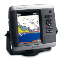
Details the initial power-on process, including the warning page and satellite acquisition.
Guides users on setting a direct destination for navigation in Aviation Mode.
Explains how to create and save flight plans (routes) for future navigation.
Provides an overhead view of terrain and obstacles, with color-coded alerts.
Displays GPS-derived data graphically, similar to an instrument panel, including the HSI.
Displays waypoints, course, distance, and ETA for the active route or Go To destination.
Provides a quick reference for navigation data, including a compass ribbon and user-selectable fields.
Provides a calculator for Density Altitude, True Airspeed, and Winds Aloft.
Guides on starting navigation to a point using various methods in Automotive Mode.
Guides on using the Find Menu to search for waypoints and points of interest.
Guides on creating and storing routes with up to 300 waypoints.
Covers methods for creating and storing waypoints, including marking present location.
Explains how the unit guides you to your destination using map and route pages.
Explains the electronic breadcrumb trail (track log) and its management.
Explains navigation options like Go To Point and Man OverBoard in Marine Mode.
Refers to Aviation section for Map Page details, highlighting marine-specific data fields.
Explains DSC technology for marine VHF radio, distress calls, and position reports.
Allows users to set and manage alarms for different operational parameters.
Guides on setting screen features, page sequence, and backlight behavior.
Allows customization of unit sounds and voice prompts.
Provides access to system settings for customization.
Guides on accessing weather information via the Map Page, Weather tab, or Find menu.
Guides on adjusting weather display options and zoom ranges via Map Page menus.