Do you have a question about the Garmin GPSMAP 420 and is the answer not in the manual?
Quick actions for navigating the device menus and functions.
Explains how to interpret instructions and navigation cues in the manual.
A list of frequently accessed topics with direct page references.
Critical warnings about safe operation and potential hazards.
Information regarding the accuracy and completeness of map data.
Information on recycling electronics according to California law.
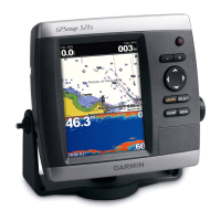
Identifies the main components and ports of the GPSMAP 400 series unit.
Instructions on how to power the device on and off.
Details on how to modify screen brightness and day/night modes.
Explains the function of each button on the device's control panel.
Process for obtaining GPS location data and troubleshooting.
Guide on resetting the unit to its original factory configuration.
Instructions for managing SD cards for data storage and transfer.
Overview of the main menu and its options for accessing features.
Displays navigation data like buoys, depths, and marinas in an overhead view.
Provides a 3D perspective view from above and behind the boat for navigation.
Offers a view of bottom contours and depth soundings without navigational data.
Presents an underwater view of the sea or lake floor based on chart data.
Options to customize chart display, including appearance and data overlays.
Accessing and viewing aerial images of landmarks and marinas.
Overlaying satellite images on the navigation chart for a realistic view.
Search for and navigate to nearby points of interest like fuel, marinas, or waypoints.
How to mark, save, and manage specific locations on the chart.
Guidance on planning and navigating multi-point routes.
Customize and display numerical data like depth, speed, and GPS position.
Accessing and interpreting tide level predictions for various stations.
Provides prediction information for ocean currents, including speed and direction.
Displays sun and moon rise/set times, moon phase, and sky view.
Manage waypoints, routes, and tracks, including data transfer to/from SD cards.
Displays information about nearby vessels via AIS or DSC connections.
Adjust general system parameters like language, GPS, and simulator mode.
Set preferred units for distance, depth, temperature, speed, and position.
Configure audible alarms for navigation, system, sonar, and weather conditions.
Settings related to the boat's configuration, including keel offset.
Settings for AIS and DSC to monitor other vessels and set safe zones.
Manage XM Radio features, including channel selection and volume.
View the transducer's sonar readings in a full-screen graph.
Displays instantaneous sonar return data in a circular format.
View both 50kHz and 200kHz sonar frequencies simultaneously.
View full sonar data alongside a zoomed-in portion of the graph.
Configure universal sonar settings like color scheme and fish symbols.
Adjust detailed sonar parameters such as range, gain, beam, and zoom.
Guidelines for choosing an optimal mounting location for the unit.
Instructions for securely mounting the unit using surface or flush mount methods.
Detailed steps for assembling and installing the sonar transducer.
Specific instructions for mounting the transducer on the boat's transom.
Method for installing a transducer inside the hull without drilling.
Guide for connecting the unit's power and data cables.
How to interface the unit with external NMEA compatible equipment.
Procedures for verifying the unit's functionality after installation.
Steps to test the sonar performance of a transom-mounted transducer.
Technical details including physical dimensions, power, and performance metrics.
Instructions for registering the product for support and warranty.
Guidance on cleaning and maintaining the unit's exterior and screen.
Explains on-screen alerts and their meanings for unit operation.
Regulatory compliance information regarding radio frequency emissions.
List of available accessories to enhance unit functionality.
Details the product warranty period, terms, and conditions.