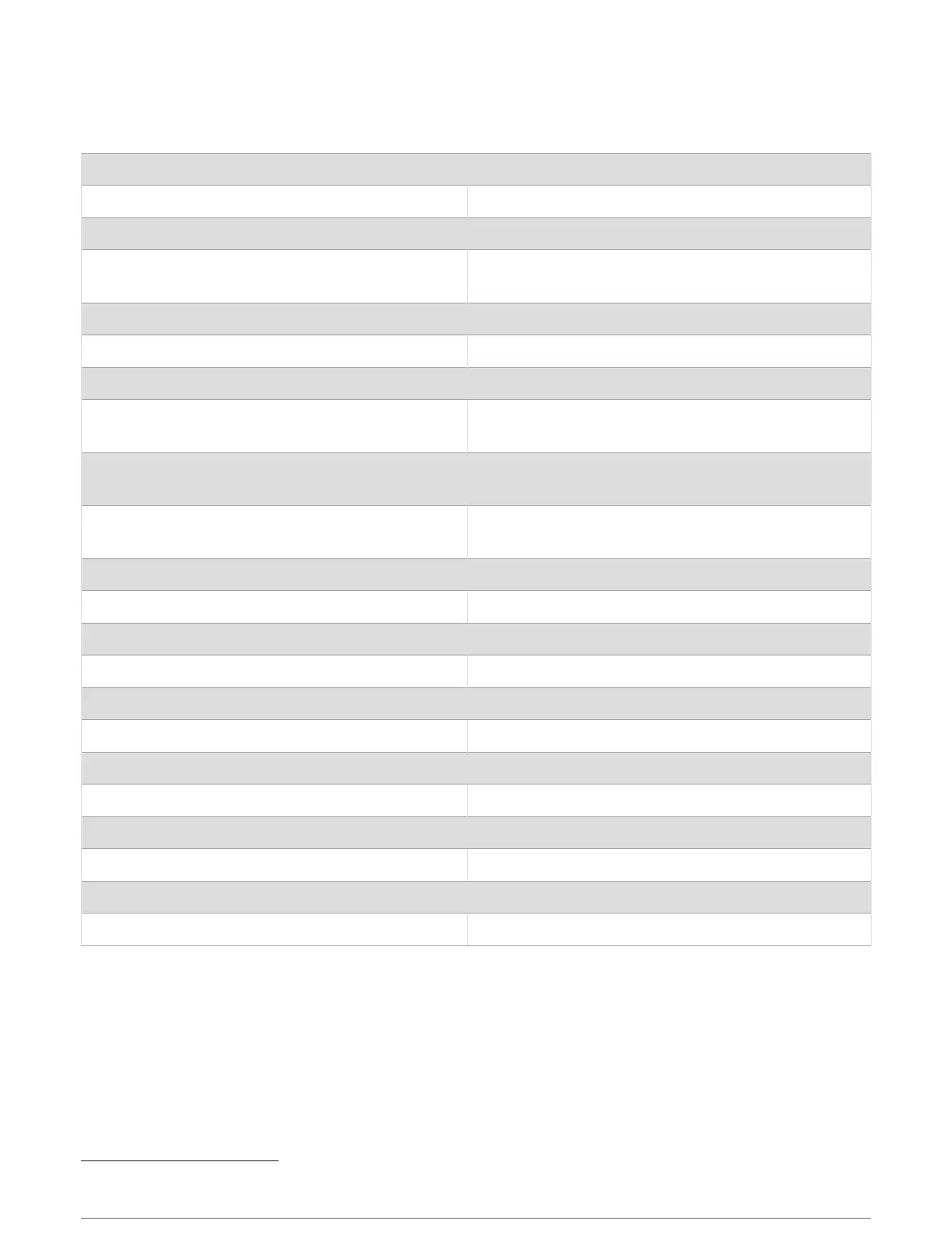
Specifications
GPSMAP 7x3 Specifications
Dimensions (W × H × D) 192.3 × 140.3 × 74.1mm (7
9
/
16
× 5
1
/
2
× 2
15
/
16
in.)
Dimensions with cover on bail mount (W × H × D) 200.2 × 156.3 × 101.2mm ( 7
7
/
8
× 6
1
/
8
× 4in.)
Clearance to next obstruction behind chartplotter 27.8mm (2in.)
Display size (W × H)
154.6 × 91.0mm (6
1
/
16
× 3
9
/
16
in.)
17.8cm (7.0in.) diagonal
Display resolution WSVGA, 1024 × 600 pixels
Weight 1.3kg (2.8lb.)
Compass-safe distance 35cm (13.78in.)
Max. power usage at 10Vdc
Non-sonar models: 17.6W
Sonar models: 35.9W
Typical current draw at 12Vdc
Non-sonar models: 1.08A
Sonar models: 1.18A
Max. current draw at 12Vdc
Non-sonar models: 1.45A
Sonar models: 2.96A
Temperature range From -15° to 55°C (from 5° to 131°F)
Material Polycarbonate plastic and die-cast aluminum
Water rating IEC 60529 IPX7
4
Input voltage From 10 to 32Vdc
Fuse 6A, 125V fast-acting
NMEA 2000 LEN @ 9Vdc 2
NMEA 2000 draw 75mA max.
Max. waypoints 5,000
Max. routes 100
Max. active track points 50,000 points, 50 saved tracks
Wireless frequency 2.4GHz @ 18.3dBm max.
Memory card 2 microSD card slots; 32GB max. card size
4
The device withstands incidental exposure to water of up to 1m for up to 30min. For more information, go to www.garmin.com/waterrating.
Appendix 187
 Loading...