EasyManuals Logo

Garmin GPSMAP 182 User Manual

Garmin GPSMAP 182
104 pages
To Next Page IconTo Next Page
To Previous Page IconTo Previous Page
Page #13 background imageLoading...
Page #13 background image
3
Getting Started
Entering Data
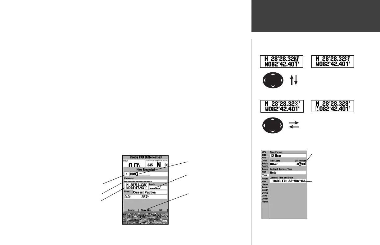
Naming a waypoint or placing any sort of data that has not been predefi ned requires the use of
both the ARROW KEYPAD and the ENTER/MARK key.
To enter a name or number in a data fi eld:
1. Once you have accessed a page with programmable data fi elds (i.e. Waypoint Edit’) you can use
the ARROW KEYPAD to move the cursor (Highlight) to fi elds on the page. Use the UP/DOWN
arrows to move up or down and the LEFT/RIGHT arrows to move sideways.
2. Pressing the ENTER/MARK key with the fi eld highlighted begins the process for entering data in
the form of alphanumeric characters.
3. Use the ARROW KEYPAD UP/DOWN arrows to cycle through numbers 0 to 9, plus/minus symbols,
blank space, and the alphabet. Pressing and releasing the keypad moves you character by character
through the list. Pressing and holding the keypad moves you rapidly through the list.
4. Use the ARROW KEYPAD LEFT/RIGHT arrows to move to the next character on the line or
backwards to edit characters. If there are more than two lines of data, keep pressing to the RIGHT
to drop down to the next line.
5. When data entry is completed press ENTER/MARK to accept data, then move to the next
programmable fi eld. Not all data fi elds are programmable, like the date and time. When moving
about a page with these type of fi elds, the cursor will skip over them.
Every fi eld and button on this page
can be programmed or activated.
A waypoint symbol can be selected
from a list of symbols.
• A comment can be added.
• The coordinates can be changed.
Pressing UP or DOWN
on the ARROW KEYPAD
changes numbers and let-
ters.
Pressing LEFT or RIGHT
on the ARROW KEYPAD
moves the cursor along the
line or to the next line.
• The waypoint can be renamed.
• A depth can be entered.
• Option buttons can be activated.
Data Entry Field
Non-programable
data fi elds
182C Manual Part 1.indd 3 6/4/2003, 2:52:15 PM

Other manuals for Garmin GPSMAP 182

Questions and Answers:

Question and Answer IconNeed help?

Do you have a question about the Garmin GPSMAP 182 and is the answer not in the manual?

Garmin GPSMAP 182 Specifications

GPSMAP 182/182C

Display IconDisplay
display size5.5" diagonal (14.0 cm)
display typehigh-resolution, 10-level grayscale LCD with backlighting
display resolution240 x 360 pixels
Power IconPower
power source8-35v DC
power usage4 watts max. at 13.8v DC
Operating Environment IconOperating Environment
temperature range5ºF to 158ºF (-15ºC to 70ºC)
caseFully gasketed, high impact plastic alloy, waterproof to IEC 529 IPX7 standards
antennaGA 29 remote marine mount with 30' cable or bail mount antenna
GPS Performance IconGPS Performance
receiverWAAS enabled, 12 parallel channel GPS receiver
acquisition time (warm)Approximately 15 seconds
acquisition time (cold)Approximately 45 seconds
Weight and Dimensions IconWeight and Dimensions
width6.3"
height6.2"
depth2.6"
weight1.7 lbs. (.77 kg)

GPSMAP 232

Display IconDisplay
display size7.1" diagonal (18.0 cm)
display typehigh-resolution, 10-level grayscale LCD with backlighting
display resolution240 x 360 pixels
Power IconPower
power source8-35v DC
power usage4 watts max. at 13.8v DC
Operating Environment IconOperating Environment
temperature range5ºF to 158ºF (-15ºC to 70ºC)
caseFully gasketed, high impact plastic alloy, waterproof to IEC 529 IPX7 standards
antennaGA 29 remote marine mount with 30' cable
GPS Performance IconGPS Performance
receiverWAAS enabled, 12 parallel channel GPS receiver
acquisition time (warm)Approximately 15 seconds
acquisition time (cold)Approximately 45 seconds
Weight and Dimensions IconWeight and Dimensions
width7.7"
height7.5"
depth2.6"
weight2 lbs. (.91 kg)

Related product manuals