Note: An example of an MGRS coordinate would be 19TDJ3858897366, which consists of:
• 19 is the UTM Zone Number
• T is the corresponding UTM latitude band letter
• DJ is the MGRS Grid Reference used to define the 100 km square within the UTM/UPS block. The
columns A-Z (excluding "I" and "O"), like UTM, start at 180° and increase towards the East. Every
three columns, the pattern repeats. Letters designating rows, increase towards the North. The letters
cycle backwards through the alphabet in the southern hemisphere (towards the South):
- D is the MGRS column letter
- J is the MGRS row letter
• 38588 is the 5–digit MGRS Easting value. It represents the number of meters East of the origin (that is,
southwest corner) of the 100 km square in which it is contained.
• 97366 is the 5–digit MGRS Northing value. It represents the number of meters North of the origin (that
is, southwest corner) of the 100 km square in which it is contained.
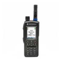
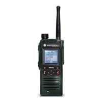
MGRS Support feature can be programmed in CPS. The user can choose to display the GPS coordinates in MGRS
format.
This is a selling feature.
GPS Different Location Displays
Table 10: Different Location Displays
Latitude / Longi-
tude
UK Coordinates Irish Coordinates UTM Coordinates
MGRS Coordi-
nates
Time Time Time Time Time
Latitude 2–Letter Code 1–Letter Code 3–Letter Code 3–Letter Code and 2–
Letter Code
Longitude Easting and Northing
Coordinate
Easting and Northing
Coordinate
Easting and Northing
Coordinate
Easting and Northing
Coordinate
Altitude Altitude Altitude Altitude Altitude
Satellites Satellites Satellites Satellites Satellites
• Time — indicates when the last time the location was calculated. The time is provided in Universal Time
Coordinated.
• Letter Code — grid zone or square on the map for different coordinate standard
• Latitude — expressed in degrees, minutes, and seconds.
• Longitude — expressed in degrees, minutes, and seconds.
• Number of satellites — used to calculate the location. In general, more satellites make for better accuracy. The
maximum is 12 satellites.
• Easting — refers to the eastward-measured distance expressed in meters.
• Northing — refers to the northward-measured distance expressed in meters.
Note: Skipping each digit of easting and northing coordinates decreases the accuracy by the factor of 10.
68 | Services and Features
Send Feedback | |
 Loading...