Black plate (43,1)
5 Touch [Start Navigation].
Your navigation system starts the route gui-
dance.
= For details of the route guidance, refer to
Understanding the route guidance on page
32.
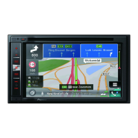
Using the “Map Location”
screen
Once a location is searched, the “Map Loca-
tion” screen appears. You can select some op-
tions for the route or displayed map location
before route calculation.
13 42
5
76
p If you touch the map, the cursor is placed
at that position. Also, you can scroll the
map by dragging the map.
1 Zoom in/zoom out
p You can also pinch or expand the map
to zoom in or out.
2 Cancels the “Map Location” screen and dis-
plays the map of the current position.
3 Returns the cursor to the initial position and
the map scale to the initial scale.
4 Shows the route setting preferences for route
calculation. Touch the keys to activate or deac-
tivate the preference.
Calculates the route prioritising
the use of motorways when the
key is activated.
Calculates the route prioritising
the use of per-use charged toll
roads when the key is activated.
Calculates the route prioritising
the use of ferries when the key
is activated.
5 Returns to the previous screen.
6 Sets the cursor position to your destination (or
waypoint).
7 Displays the shortcuts.
! Detailed Information:
Shows the detailed information of the
point.
! Save Location:
Saves the displayed location as your fa-
vourite location. The saved location can
be easily recalled later.
! Places Around Cursor:
Searches for POIs around the displayed
location. Touch the POI to show the
“Map Location” screen, and also set
the POI as the destination (or
waypoint).
<CRB4523-A>43
Engb
43
Chapter
05
Searching for a destination
Searching for a destination

 Loading...