EasyManuals Logo

Raymarine GPS Plotter User Manual

Raymarine GPS Plotter
131 pages
To Next Page IconTo Next Page
To Previous Page IconTo Previous Page
Page #34 background imageLoading...
Page #34 background image
Chapter 3: Operation 3-5
Waypoint Data
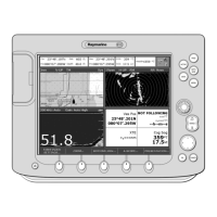
The Waypoint Data display comprises three data pages, selected in turn
by the
WPT DATA soft key. These pages are shown in Figure 3-5 to
Figure 3-7:
Figure 3-5: Waypoint Data #1
Figure 3-6: Waypoint Data #2
D4940-2
XTE
0.06nm
01h:00m
050°M
TTG
COG
SOG
ROUTE GOTO GPS DATA WPT DATA
SD-FIX
STEER STARBOARD
WPT 004
12.0kts
BRG 320°M
RNG 0.55nm
D4941-2
XTE
0.06nm
01h:00m
TTG
ETA
TIME
ROUTE GOTO GPS DATA WPT DATA
SD-FIX
STEER STARBOARD
WPT 004
12:34:00
13:34:00
BRG 320°M
RNG 0.55nm
81171_4.BOOK Page 5 Thursday, November 29, 2001 11:34 AM

Table of Contents

Questions and Answers:

Question and Answer IconNeed help?

Do you have a question about the Raymarine GPS Plotter and is the answer not in the manual?

Raymarine GPS Plotter Specifications

General IconGeneral
BrandRaymarine
ModelGPS Plotter
CategoryGPS
LanguageEnglish

Related product manuals