Dctailcd
Opcration
€rj
JÐ
aÐ
ð
ð
ð
ð
-Ð
JÐ
JÐ
JÐ
aÐ
iÐ
ð
-Ð
J-
a-
€
.Ð
j-
¿-
a-
Y-
Èa
.)
¿-
r-
e-
tt-
e-
z-
e-
e-
Q-
ea
ea
ca
ea
ea
aa
€
Flisht Plan
(FPL)
Function
Use the Flight Plan function to
view
details about your
flight
plan
route. Press the UP/DOWN arrow
"smart"
keys
to step through the
waypoints in your flight plan. Press
the
INFO
"smart"
key to view information about the
waypoint.
The Flight Plan Function shows the Current
Flight Plan that is active in the connected navigation
source
(i.e.
GPS
receiver).
The Current To
Waypoint
box
show's the current
leg
of the
flight plan.
The Current
Flight Plan box shows all of the
legs
of your flight
plan
with the current leg indicated in magenta. Listed are each
leg with the bearing and distance between
the
legs. The
Current Nav Data box shows the aircraft current position
in latitude and
longitude, ground
speed, and track. In the
lower
right
corner
information for
the current
waypoint
is
displayed
in the
Waypoint
Info box. The Flight Plan
function does not have any options.
Runway diagrams of airports
will
be displayed in the same
orientation as the main map
(i.e.,
North Up, Track Up, or
DTK Up).
l)cailcd
Opcration
Terain
(TER)
Function
The
Terrain
F
area
relative
to your
airplane's
position
and
altitude.
The
ahitude
information
comes
from
an external
altitude
encoder.
The
displayed
altimeter
setting
has
ro
be
adjusted,
or baro-corrected, just
like
the
one
in your
aircraft 's
instrument
panel.
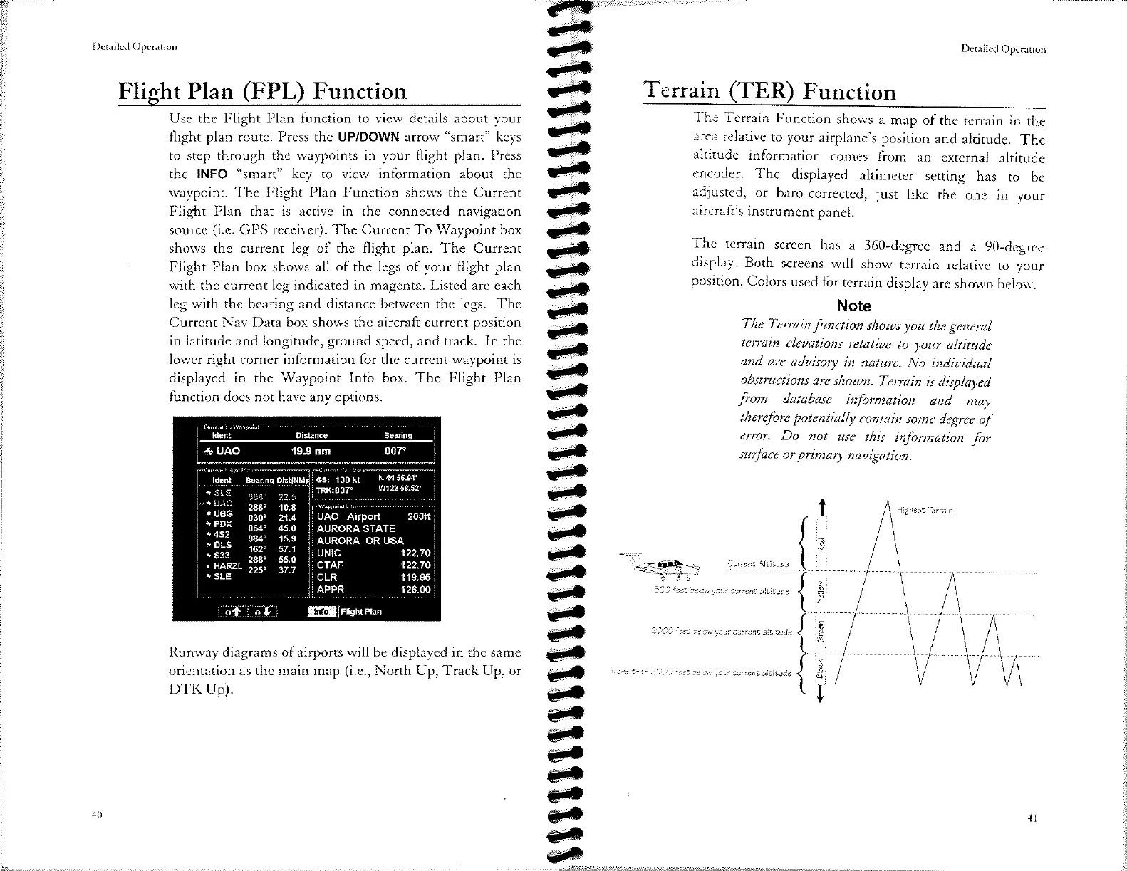
The
terrain
screen
has a
360-degree
and
a 9O-degree
display.
Both
screens
will
show
terrain
relative
ro your
position.
Colors
used
for
terrain
display
are
shown
below.
Note
The Terraìn
function
slzouts
you
the general
tenain
elcaations
relatiue
to your
altitude
and are
aduisoty
in
nature.
No indiuidual
obstructíons
are
shoun.
Teryain
is
displayed
fro*
database
informøtion
and
møy
thereþre
potentially
contain
some
degree
of
error.
Do not
ute
this
inþtmation
þr
surface
or
primary
nauigation.
':-<æt+
Cu.rcnÞAttitude
-13
¿r-
ze
cu
your
cur.cnt
altitu¿c
'z)33 ¿r-
æ ct
yct.
currcnt
altiludc
r
:1 a'j'
'.4
a i
.a-
.a
"'¿
rvct.
cur.¿ñr¿
âlfituàc
ldent O¡stànce
+ UAO 19.9
nm
007"
tdenl Beârino oistiNMt Gs: 100 kt
N.l4 56.94'
TRK:007o
w122 58.52.
'
zeg. io.8
"
YP9
o3o" 21.4
uAo A¡rport zooft
: î:I
064" 45.0
AURoRA
srAre
-:::
084"
'rs.s
AURoRA oR USA
_ I"'.'
162" s7.1
UN|C 122.70
.
ñ;"
i::" ?19
crAF 12270
'sLE
CLR 119.95
APPR 126.00
¡1 ,¡l
@
jrticlrrcturr
t_--