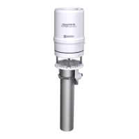
3. Orient the ClimaVUE 50 so that the engraved N points to True North (FIGURE 7-3 (p. 15)).
Determining True North and sensor orientation (p. 38) contains detailed information on
determining True North using a compass and the magnetic declination for the site.
FIGURE 7-3. Engraved N on the ClimaVUE 50
4. Use a torpedo level or the bubble level underneath the sensor to level it (FIGURE 7-4 (p.
15)). The angle of the instrument mount may need to be adjusted if the mast is not vertical.
Shims can be added between the top of the mast and the bottom of the ClimaVUE 50 to
achieve level. The sensor must be within ±2° of dead level (0, 0) in both the X and Y
directions to accurately measure rainfall and solar radiation. The ±2° can be confirmed by
viewing the Tilt North(+)/South(–) and Tilt West(+)/East(–) orientation values returned by
the R7! command.
FIGURE 7-4. Bubble level on the ClimaVUE 50
ClimaVUE 50 Compact Digital Weather Sensor 15
 Loading...