10
©
2022 DJI All Rights Reserved.
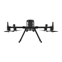
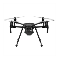
MATRICE 30 SERIES User Manual
Feature Highlights
PinPoints:
A PinPoint can be added for a target to select a point of interest in the gimbal camera view.
Besides generating its longitude and latitude, a PinPoint can be used to search and mark points of
interest, such as emergency rescues, security operations, and surveillance.
Live Annotations:
Users can add PinPoints, lines, and areas in the map view of the remote controller
and DJI FlightHub 2. Share annotation data to the companion controller in the Dual Control mode and
other devices logged in to DJI FlightHub 2. Data is shared in real time which facilitates operations across
the air and ground.
AR Projection:
DJI Pilot 2 supports the projection of Home Point, PinPoint, and Waypoint locations
in the FPV camera view or the gimbal camera view, providing users with clear ight targets and better
situation awareness.
Cloud Mapping:
When the remote controller is logged in to DJI FlightHub 2, the aircraft can perform a
cloud mapping task, which enables viewing of and generates a map on DJI FlightHub 2 simultaneously.*
* For more details, refer to the DJI FlightHub 2 User Guide which is available to download from the ocial DJI
website https://www.dji.com/ighthub-2/downloads.

 Loading...