9
EN
System Accuracy (RMS 1σ)* Horizontal: 10 cm @ 50 m
Vertical: 5 cm @ 50 m
Real-Time Point Cloud Coloring Coding Reectivity, Height, Distance, RGB
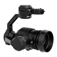
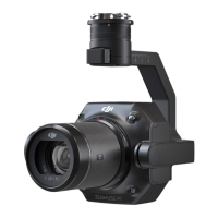
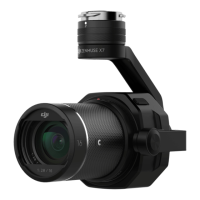
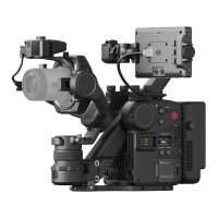
LiDAR
Ranging Accuracy (RMS 1σ)* 3 cm @ 100 m
Maximum Returns Supported 3
Scan Modes Non-repetitive scanning pattern, Repetitive scanning pattern
FOV Non-repetitive scanning pattern: 70.4° (horizontal) × 77.2°
(vertical)
Repetitive scanning pattern: 70.4° (horizontal) × 4.5° (vertical)
Laser Safety Class 1 (IEC 60825-1:2014) (Eye Safety)
Inertial Navigation System
IMU Update Frequency 200 Hz
Accelerometer Range ±8 g
Angular Velocity Meter Range ±2000 dps
Yaw Accuracy (RMS 1σ)* Real-time: 0.3°, Post-processing: 0.15°
Pitch/Roll Accuracy (RMS 1σ)* Real-time: 0.05°, Post-processing: 0.025°
Auxiliary Positioning Vision Sensor
Resolution 1280×960
FOV 95°
RGB Mapping Camera
Sensor Size 1 in
Eective Pixels 20 MP
Photo Size 5472×3078 (16:9), 4864×3648 (4:3), 5472×3648 (3:2)
Focal Length 8.8/24 mm (equivalent)
Shutter Speed Mechanical shutter speed: 1/2000-8 s
Electronic shutter speed: 1/8000-8 s
ISO Video: 100-3200 (auto), 100-6400 (manual)
Photo: 100-3200 (auto), 100-12800 (manual)
Aperture Range f/2.8 - f/11
Supported File System
FAT (≤32 GB); exFAT (>32 GB)
Photo Format JPEG
Video Format MOV, MP4
Video Resolution H.264, 4K: 3840×2160 30p
Gimbal
Stabilized System 3-axis (tilt, roll, pan)
Angular Vibration Range ±0.01°
Mount Detachable DJI SKYPORT
 Loading...