2. SYSTEM MENU
28
3. Use W or X to select the nav data item to
display. Availability depends on how
much nav data is displayed, as shown be-
low.
4. Press the [ENTER] key.
Note: When data is lost 30 sec., the display
shows “- -” at the location where there is no
data.
Item Necessary data
Latitude/Longitude.
Waypoint, Course,
Range/Bearing, TTG,
XTE
Latitude and longi-
tude
Compass, Heading Heading
Wind Speed/Direction,
Atmospheric Pressure
Wind Indicator, Ba-
rometer
Two-data
display
Three-data
display
Four-data
display
(1)
(2)
(3)
(4)
(5)
(6)
(7)
(8)
(9)
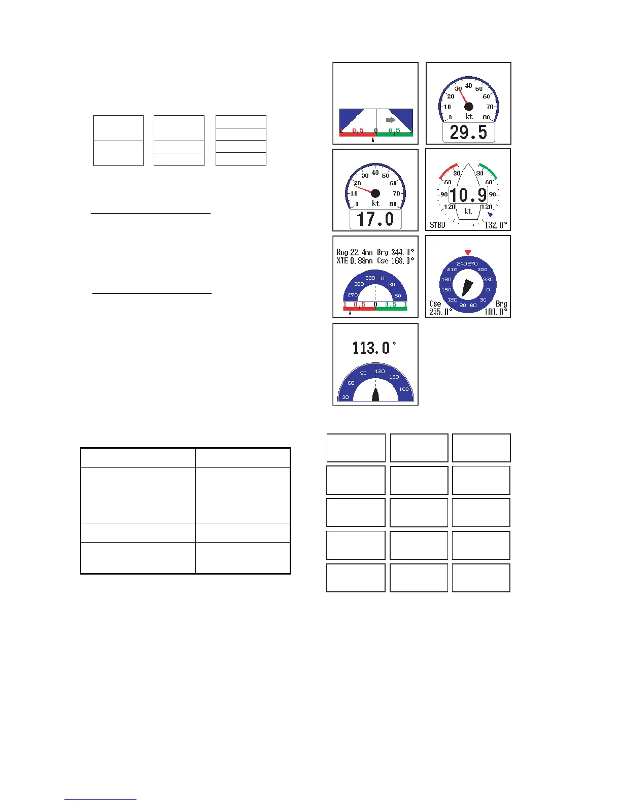
Items displayable in (1) - (3): speed (STW)*,
wind speed and direction*, destination
waypoint data*, compass*, heading*, depth,
position, course, range and bearing,
trip meter, odometer, water temperature,
air pressure, time-to-go to destination
waypoint, XTE*, speed (SOG)*
Items displayable in (4) - (9): depth, position,
speed (SOG), speed (STW), course,
range and bearing, trip meter, odometer,
water temperature, heading, wind speed,
wind direction, air pressure, time-to-go to
destination waypoint, XTE
* = Graphic display
XTE
XTE
0.20
nm
27.3
nm
Rng
PORT
SPEED (SOG)
SPEED (STW) WIND
WPT COMPASS
HEADING
SOG: Speed over
ground
STW: Speed relative
to water
True
True
MARINA
MARINA
True
1234
ft
DEPTH
23
45.6789
'N
123
45.6789
'E
POSITION
12.3
kt
SPEED (SOG)
12.3
kt
SPEED (STW)
123.4
COURSE True**
1234
nm
123.4
RNG/BRG***
°
°
°
°
1234
nm
TRIP METER
1234
nm
ODOMETER
TEMP
°
123.4
F
HEADING True**
WIND
SPEED True*
123.4
°
12.3
kt
WIND
DIR. True*
123.4
°
BAROM PRESS
TIME TO GO
1234
hPa
12
H
34
M
XTE
0.50
nm
* APP or TRUE, depending on menu setting.
** TRUE or MAG depending on menu setting.
*** To destination waypoint.
(green): starboard (red): port
STBD
01