(Connecting to the Garmin Quickdraw
Community with
ActiveCaptain,
page
11).
1
Insert the memory card into your computer.
2
Access the
Garmin Quickdraw Community (
Connecting to the
Garmin Quickdraw Community with
Garmin Connect
,
page 11)
.
3
Select
Search for Contours.
4
Use the map and search features to locate an area to
download.
The red dots represent Garmin Quickdraw Contours maps
that have been shared for that region.
5
Select
Select an Area to Download.
6
Drag the edges of the box to select the area to download.
7
Select
Start Download.
8
Save the file to your memory card.
TIP: If you cannot find the file, look in the "Downloads" folder.
The browser may have saved the file there.
9
Remove the memory card from your computer.
10
Insert the memory card into the chartplotter.
The chartplotter automatically recognizes the contours maps.
The chartplotter may take a few minutes to load the maps.
Garmin Quickdraw Contours Settings
From a chart, select
MENU
> Quickdraw Contours > Settings
.
Display
: Displays Garmin Quickdraw Contours. The User
Contours option shows your own Garmin Quickdraw
Contours maps. The Community Contours option shows the
maps you have downloaded from the Garmin Quickdraw
Community.
Recording Offset: Sets the distance between the sonar depth
and the contour recording depth. If the water level has
changed since your last recording, adjust this setting so the
recording depth is the same for both recordings.
For example, if the last time you recorded had a sonar depth
of 3.1 m (10.5 ft.), and today's sonar depth is 3.6 m (12 ft.),
enter -0.5 m (-1.5 ft.) for the a Recording Offset value.
User Display Offset: Sets differences in contour depths and
depth labels on your own contours maps to compensate for
changes in the water level of a body of water, or for depth
errors in recorded maps.
Comm. Display Offset: Sets differences in contour depths and
depth labels on the community contours maps to compensate
for changes in the water level of a body of water, or for depth
errors in recorded maps.
Survey Coloring: Sets the color of the Garmin Quickdraw
Contours display. When this setting is turned on, the colors
indicate the quality of the recording. When this setting is
turned off, the contour areas use standard map colors.
Green indicates good depth and GPS position, and a speed
under 16 km/h (10 mph). Yellow indicates good depth and
GPS position, and a speed between 16 and 32 km/h (10 and
20 mph). Red indicates poor depth or GPS position, and a
speed above 32 km/h (20 mph).
Depth Shading: Specifies the minimum and maximum depths of
a depth range and a color for that depth range.
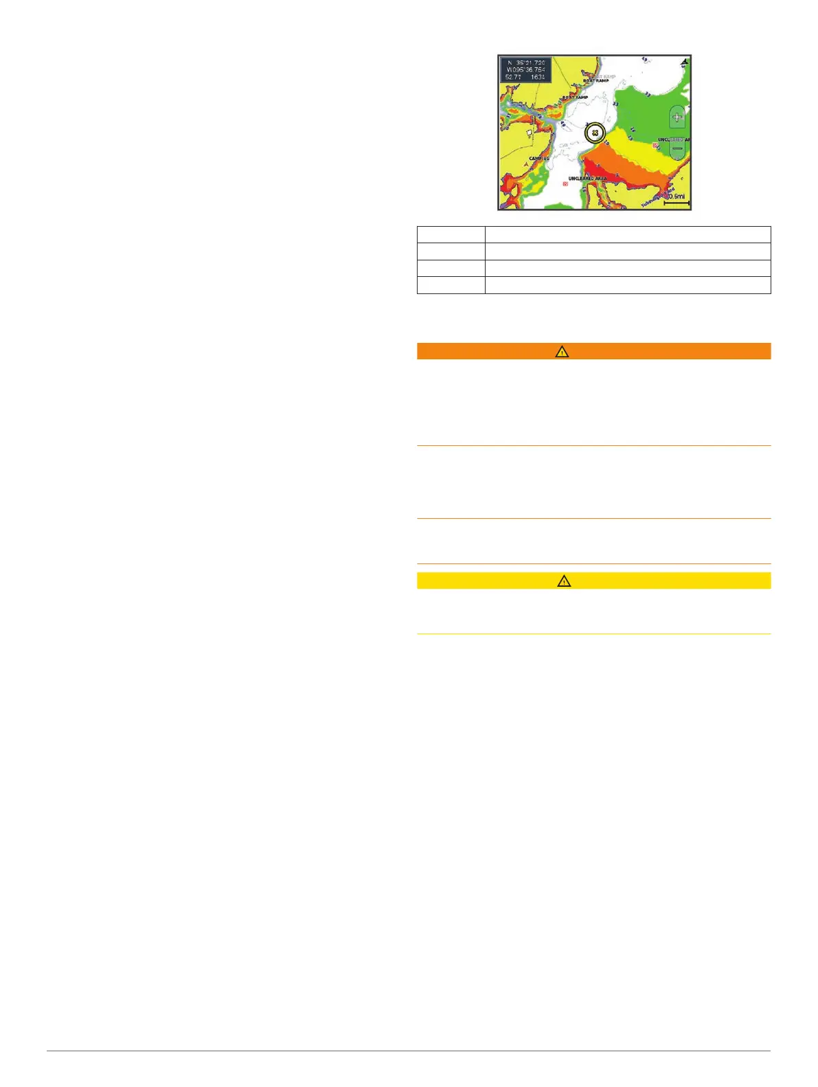
Depth Range Shading
You can set color ranges on your map to show the water depths
where your target fish are currently biting. You can set deeper
ranges to monitor how quickly the bottom depth changes within
a specific depth range. You can create up to ten depth ranges.
For inland fishing, a maximum of five depth ranges can help
reduce map clutter.
Red From 0 to 1.5 m (from 0 to 5 ft.)
Orange From 1.5 to 3 m (from 5 to 10 ft.)
Yellow From 3 to 4.5 m (from 10 to 15 ft.)
Green From 4.5 to 7.6 m (from 15 to 25 ft.)
Navigation with a Chartplotter
WARNING
A magenta line displayed on the chartplotter is only intended to
provide general route guidance or to identify proper channels,
and it is not intended to be precisely followed. Always defer to
the navaids and conditions on the water when navigating to
avoid groundings or hazards that could result in vessel damage,
personal injury, or death.
The Auto Guidance feature is based on electronic chart
information. That data does not ensure obstacle and bottom
clearance. Carefully compare the course to all visual sightings,
and avoid any land, shallow water, or other obstacles that may
be in your path.
When using Go To, a direct course and a corrected course may
pass over land or shallow water. Use visual sightings, and steer
to avoid land, shallow water, and other dangerous objects.
CAUTION
If your vessel has an autopilot system, a dedicated autopilot
control display must be installed at each steering helm in order
to disable the autopilot system.
NOTE:
Some chart views are available with premium charts, in
some areas.
To navigate, you must choose a destination, set a course or
create a route, and follow the course or route. You can follow
the course or the route on the Navigation chart, Fishing chart,
Perspective 3D chart view, or Mariner’s Eye 3D chart view.
You can set and follow a course to a destination using one of
three methods: Go To, Route To, or Auto Guidance.
Go To: Takes you directly to the destination. This is the
standard option for navigating to a destination. The
chartplotter creates a straight-line course or navigation line to
the destination. The path may run over land and other
obstacles.
Route To: Creates a route from your location to a destination,
allowing you to add turns along the way. This option provides
a straight-line course to the destination, but allows you to add
turns into the route to avoid land and other obstacles.
Auto Guidance: Uses the specified information about your
vessel and chart data to determine the best path to your
destination. This option is available only when using a
compatible premium chart in a compatible chartplotter. It
provides a turn-by-turn navigation path to the destination,
avoiding land and other obstacles (Auto Guidance
,
page
15)
.
When you are using a compatible Garmin
autopilot
connected to the chartplotter using NMEA 2000
®
, the
autopilot follows the Auto Guidance route.
12 Navigation with a Chartplotter
 Loading...