My device will not turn on or keeps turning off
Devices erratically turning off or not turning on could indicate an
issue with the power supplied to the device. Check these items
to attempt to troubleshoot the cause of the power issue.
• Make sure the power source is generating power.
You can check this several ways. For example, you can
check whether other devices powered by the source are
functioning.
• Check the fuse in the power cable.
The fuse should be located in a holder that is part of the red
wire of the power cable. Check that the proper size fuse is
installed. Refer to the label on the cable or the installation
instructions for the exact fuse size needed. Check the fuse to
make sure there is still a connection inside of the fuse. You
can test the fuse using a multimeter. If the fuse is good, the
multimeter reads 0 ohm.
• Check to make sure the device is receiving is at least 10 V,
but 12 V is recommended.
To check the voltage, measure the female power and ground
sockets of the power cable for DC voltage. If the voltage is
less than 10 V, the device will not turn on.
• Make sure the device is firmly secured in the cradle. If the
model uses a locking bracket, make sure the bracket is firmly
snapped close. There is an audible click when the device or
locking bracket is installed correctly. If the device is not firmly
secured, it can lose power. The device can also fall out of the
cradle and become damaged if it is not firmly secured.
• If the device is receiving enough power but does not turn on,
contact Garmin product support at support.garmin.com.
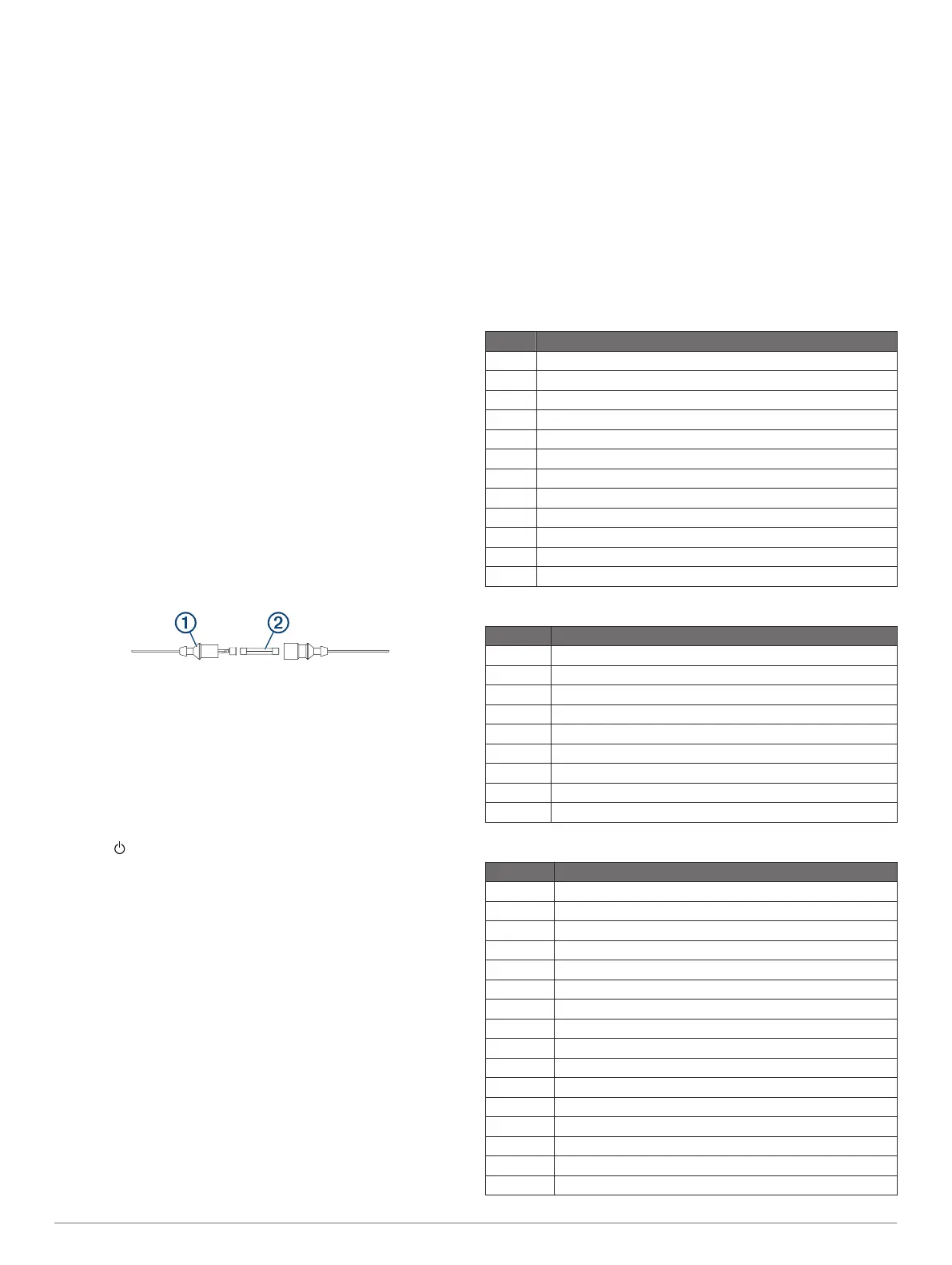
Changing the Fuse in the Power Cable
1
Open the fuse housing
À
.
2
Twist and pull the fuse to remove it
Á
.
3
Insert a new 3 A fast-blow fuse.
4
Close the fuse housing.
My sonar does not work
• Push the transducer cable all the way into the back of the
device.
Even if the cable seems to be connected, you should push
firmly so that it is fully seated.
• Press , and ensure sonar is enabled.
• Select the correct transducer type (Selecting the Transducer
Type,
page
21)
.
My device is not creating waypoints in the correct
location
You can manually enter a waypoint location to transfer and
share data from one device to the next. If you have manually
entered a waypoint using coordinates, and the location of the
point does not appear where the point should be, the map
datum and position format of the device may not match the map
datum and position format originally used to mark the waypoint.
Position format is the way in which the GPS receiver's position
appears on the screen. This is commonly displayed as latitude/
longitude in degrees and minutes, with options for degrees,
minutes and second, degrees only, or one of several grid
formats.
Map datum is a math model which depicts a part of the surface
of the earth. Latitude and longitude lines on a paper map are
referenced to a specific map datum.
1
Find out which map datum and position format was used
when the original waypoint was created.
If the original waypoint was taken from a map, there should
be a legend on the map that lists the map datum and position
format used to create that map. Most often this is found near
the map key.
2
Select Settings > Units.
3
Select the correct map datum and position format settings.
4
Create the waypoint again.
My device does not display the correct time
Time is set by GPS position and time zone setting.
1
Select Settings
> Units > Time Zone
.
2
Ensure the device has a GPS fix.
NMEA 2000 PGN Information
Transmit and Receive
PGN Description
059392 ISO acknowledgment
059904 ISO request
060928 ISO address claim
126208 NMEA
: Command, request, and acknowledge group function
126996 Product information
127250 Vessel heading
128259 Speed: Water referenced
128267 Water depth
129539 GNSS DOPs
129799 Radio frequency, mode, and power
130306 Wind data
130312 Temperature
Transmit
PGN Description
126464 Transmit and receive PGN list group function
127258 Magnetic Variance
129025 Position: Rapid update
129026 COG and SOG: Rapid update
129029 GNSS position data
129283 Cross track error
129284 Navigation data
129285 Navigation route and waypoint info
129540 GNSS satellites in view
Receive
PGN Description
127245 Rudder
127250 Vessel heading
127488 Engine parameters: Rapid update
127489 Engine parameters: Dynamic
127493 Transmission parameters: Dynamic
127498 Engine parameters: Static
127505 Fluid level
129038 AIS class A position report
129039 AIS class B position report
129040 AIS class B extended position report
129794 AIS class A static and voyage related data
129798 AIS SAR aircraft position report
128000 Nautical leeway angle
129802 AIS safety-related broadcast message
129808 DSC call information
130310 Environmental parameters
Appendix 39
 Loading...