Do you have a question about the Garmin ECHOMAP UHD2 5 Series and is the answer not in the manual?
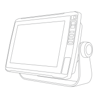
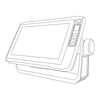
Overview of the device's physical layout, including key buttons and ports.
Explains the function of each button on the device for user interaction.
Identifies and describes the ports on the device for external connections.
Provides useful operational tips and quick methods for common device functions.
Information on where to find help, product manuals, and customer support.
Steps and information on how the device obtains GPS signals for positioning.
How to choose the preferred GPS data source if multiple are available.
Overview of the chartplotter's main interface and its accessible features.
Instructions on how to customize the layout and order of home screen items.
General guidance on personalizing display pages and their content.
Guide to customizing pages that display multiple data panes simultaneously.
Explains the different user roles (Owner, Guest) and their app capabilities.
Instructions for initial setup and connection of the ActiveCaptain mobile app.
How to update device software using the ActiveCaptain mobile application.
How to download and transfer chart updates via the ActiveCaptain app.
Steps to configure the device's Wi-Fi network for wireless sharing.
Guide on pairing two devices for wireless data and sonar sharing.
Common issues and solutions for wireless connectivity problems.
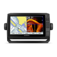
Details on the standard navigation chart and the specialized fishing chart.
Key to understanding the various symbols used on the detailed charts.
Instructions for setting a course to a selected point on the chart.
Overview of options and settings available within the chart menu.
Explanation of the underwater 3D view for fishing and bathymetry.
Step-by-step guide to recording depth contours for custom maps.
Information about the online community for sharing and downloading contour maps.
How to access the community via the ActiveCaptain mobile application.
Sets the distance between sonar and contour recording depths.
FAQ addressing common navigation tasks and feature usage.
Explains the meaning of different colors used for route lines on the chart.
How to select and navigate to various destinations.
Instructions for navigating directly to a selected point.
How to save the current device position as a waypoint.
How to create waypoints at specific coordinates or on the chart.
Special function to mark MOB locations for quick return navigation.
How to access and review all saved waypoints on the device.
How to create and immediately navigate a route without saving it.
Step-by-step guide to creating and saving multi-turn navigation routes.
How to locate and follow previously saved navigation routes.
Step-by-step instructions for using Auto Guidance for navigation.
How to create and save custom Auto Guidance paths.
Settings to customize how Auto Guidance calculates navigation paths.
How to display recorded boat tracks on the chart.
How to save the currently recorded track for later use.
How to modify saved tracks, including color and conversion to routes/boundaries.
How to locate and follow previously saved boat tracks.
Steps to create new boundary shapes (areas, lines, circles) on the chart.
How to modify existing boundaries and their display options.
How to set alarms for entering or exiting defined boundaries.
How to disable or turn off sonar signal transmission.
Explanation of the standard, full-screen sonar display view.
Details on the Garmin ClearVü scanning sonar technology.
Explanation of the circular depth-based sonar display.
How to adjust zoom levels for detailed sonar viewing.
How to adjust the speed at which sonar data scrolls across the screen.
How to adjust the depth range displayed on the sonar screen.
How to reduce interference and clutter on the sonar screen.
How to access and display various gauges for engine and environmental data.
How to customize the data displayed in individual gauges.
How to add, remove, or change gauge pages and layouts.
How to adjust the time and depth scales for graphical data displays.
How to access and review system warning and alarm messages.
How to save warning messages to a memory card for later review.
General settings for the device's operating system and features.
How to configure audio alerts and visual display options.
Configuration options for GPS reception and accuracy settings.
User preferences for units, language, navigation, and keyboard layout.
How to configure various system and notification alarms.
How to set specific alarms for navigation events like arrival or off-course.
How to set alarms for sonar-related conditions like shallow or deep water.
How to compensate depth readings based on transducer installation location.
How to choose file formats for importing/exporting user data.
How to transfer user data from a memory card to the device.
How to save user data from the device to a memory card.
How to create a backup of device data on a computer.
Comparison of the ActiveCaptain mobile and Garmin Express desktop apps.
Instructions for installing the Garmin Express software on a computer.
How to update device charts using the Garmin Express application.
Information and methods for updating the device's system software.