CONTENTS
CAUTIONS . . . . . . . . . . . . . . . . . . . . . . . . . . . . . . . . . . . . 3
Geodetic Chart System . . . . . . . . . . . . . . . . . . . . . . . . .3
TERMS . . . . . . . . . . . . . . . . . . . . . . . . . . . . . . . . . . . . . 3
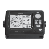
BRG (Bearing) ................................3
RNG (Range) The distance from your
vessel to a destination or Waypoint. . . . . . . . . . . . . . . . 3
SOG (Speed over Ground) .......................3
COG (Course over Ground) ......................3
XTE (Cross track error) . . . . . . . . . . . . . . . . . . . . . . . . .3
ETA (Estimated time of arrival) . . . . . . . . . . . . . . . . . . . 3
TTG (Time to go) ..............................3
Waypoint . . . . . . . . . . . . . . . . . . . . . . . . . . . . . . . . . . . 3
Route ......................................3
MAINTENANCE . . . . . . . . . . . . . . . . . . . . . . . . . . . . . . . . 3
ACQUIRING GPS SIGNALS ........................3
Satellite Display Page . . . . . . . . . . . . . . . . . . . . . . . . . .3
CONTROLS ....................................4
Using the Keypad . . . . . . . . . . . . . . . . . . . . . . . . . . . . .4
Cycling through the Displays (DISP) ................4
Highway Display ..............................5
Navigation Data Display . . . . . . . . . . . . . . . . . . . . . . . . 5
Compass Display ..............................5
Positional Navigation Data Display . . . . . . . . . . . . . . . . 6
User Configurable Navigation Displays . . . . . . . . . . . . . 6
Speedometer Display . . . . . . . . . . . . . . . . . . . . . . . . . . 6
Controlling the Plotter Display ................... 6
WAYPOINTS ...................................7
Entering a Waypoint from the
Cursor Position .............................. 7
Marking a Waypoint at the Vessels Position ..........7
Entering a Waypoint from the Waypoint List . . . . . . . . 7
Editing Waypoint Attributes . . . . . . . . . . . . . . . . . . . 8
Marking an MOB . . . . . . . . . . . . . . . . . . . . . . . . . . 8
Nearest Waypoints . . . . . . . . . . . . . . . . . . . . . . . . . 9
Proximity Waypoints . . . . . . . . . . . . . . . . . . . . . . . . 9
Editing the Proximity Waypoint List . . . . . . . . . . . . . . . .9
Erasing Waypoints ............................10
ROUTES . . . . . . . . . . . . . . . . . . . . . . . . . . . . . . . . . . . . .10
Creating Routes . . . . . . . . . . . . . . . . . . . . . . . . . . . . . 10
Creating a Route using the Cursor ................10
Creating a Route from the ROUTE Menu ...........11
Creating Routes from the Waypoint List . . . . . . . . . . 11
Creating a Track-based Route . . . . . . . . . . . . . . . . . . . 12
Editing Routes . . . . . . . . . . . . . . . . . . . . . . . . . . . . . .12
Erasing Routes ............................ 14
SETTING DESTINATIONS . . . . . . . . . . . . . . . . . . . . . . 14
Setting destinations by Cursor ................. 14
Setting destinations by Waypoint ............... 14
Setting destinations by Route . . . . . . . . . . . . . . . . . 15
Setting destinations by MOB .................. 15
Setting User Waypoints as a Destination . . . . . . . . . 15
Cancelling your Destination ................... 15
ALARMS ................................... 15
Arrival and Anchor Watch Alarms . . . . . . . . . . . . . . 16
Cross Track Error (XTE) Alarm . . . . . . . . . . . . . . . . . 16
Speed Alarm .............................. 17
Time Alarm ............................... 17
Trip Alarm ................................ 17
Odometer Alarm ........................... 17
Buzzer Selection . . . . . . . . . . . . . . . . . . . . . . . . . . . 17
OTHER NAVIGATION FUNCTIONS . . . . . . . . . . . . . . . 17
Calculating Range, Bearing, TTG and ETA . . . . . . . . 17
MAIN MENU - CONFIGURING YOUR GP450X ...... 18
GPS Setup . . . . . . . . . . . . . . . . . . . . . . . . . . . . . . . 18
Displaying the Message Board . . . . . . . . . . . . . . . . 19
SYS Setup ................................ 20
Plotter Setup .............................. 21
Clearing Data ............................. 23
INSTALLATION
. . . . . . . . . . . . . . . . . . . . . . . . . . .24
Installing the Display Unit
. . . . . . . . . . . . . . . . . .24
Installation of Antenna Unit
.................24
Grounding . . . . . . . . . . . . . . . . . . . . . . . . . . . . . . . 24
CONNECTING EXTERNAL DEVICES . . . . . . . . . . . . . . 25
Uploading and Downloading Waypoint
& Route Data . . . . . . . . . . . . . . . . . . . . . . . . . . . . . 25
Connecting to External Marine Devices
..........25
Selecting the NMEA Version
.................25
Downloading Data to a PC
..................25
Uploading Data from a PC . . . . . . . . . . . . . . . . . . . 26
Output data format, data sentences ............26
Waypoint Data Format . . . . . . . . . . . . . . . . . . . . . . 27
SPECIFICATIONS
..........................28
GP450X CUTTING TEMPLATE
.................29
STATUTORY WARRANTIES ..................... 30