Channels: 12 Parallel channels
WAAS/EGNOS/MSAS: 1 Additional channel
Waypoints: 999
Routes: 50 Routes with 30 Waypoints/Route
Tracks: 2500 points
Max Velocity: 500 m/s (972 knots)
Accuracy: <15 m (95%)
Acceleration: 4g
Altitude: 18,000 m
Acquisition Time: Hot: 15 secs
Warm: 45 Secs
Cold: 60 Secs
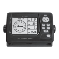
LCD Type: Monochrome
LCD Dimensions: 95 (W) x 63 (H) mm
LCD Resolution: 240 x 160 pixels
Alarms: Arrival, Anchor, Cross Track Error (XTE),
Odometer, Speed, Time, Trip
Plotter scale (range): 0.02 – 320 nm
Interface: NMEA 0183 v1.5, v2.0, v2.1
Sentences Output: GLL, GGA, VTG, ZDA, RMC, RMB, BWC, AAM, APB, BOD, XTE
Sentences Input: WPL (Waypoints)
PC Interface: Waypoint & Route Data
Power: 12 – 24 Volts
Current: 2.8 Watts (240/120 mA)
Temperature Range: Display Unit: -15C to +55C
Antenna: -25C to +70 C
Waterproofing: Receiver: IPX5
Antenna: IPX6
Coordinates: Lat/Lon DMS
Datum: WGS84
Nearest Waypoints: 7
MOB: Yes
Update rate: 1 Second
Weight: 476 g
Antenna Cable Length: 30 ft (10 m)
Compass Safe Distance: Standard Compass: 0.8 m
Steering Compass: 0.5 m
SPECIFICATIONS
19.20 mm
19.20 mm
 Loading...