IntuVueRDR-7000 Weather Radar Pilot's Guide
Introduction D201911000094
4 Rev 0, Feb 2020
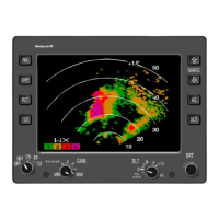
RDR-7000 OPERATIONAL ENHANCEMENTS
Automatic control of antenna tilt for reduced pilot workload
o No traditional tilt control.
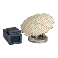
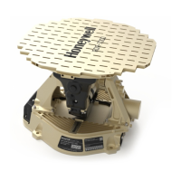
3D (Three-Dimensional) Volumetric Memory
o The entire area in front of aircraft is automatically scanned (out
to 320 nautical miles (nm) and from ground to 60,000 feet (ft)).
o All weather information is stored and continuously updated.
o Automatically corrects for curvature of the earth.
o Pilots can choose among display options as desired.
Predictive Hail and Lightning Icons (if installed)
o Areas ahead of the aircraft that have a high probability of
producing hail or lightning are indicated by the display of
appropriate icons.
REACT (Rain Echo Attenuation Compensation Technique)
o Indicates areas where attenuation of the radar signal is severe
enough to degrade the ability to display weather behind
significant intervening weather.
Vertical Display (if supported by display system)
o Indicates reflectivity along the flight plan or a selected azimuth
Weather/Turbulence Ahead Indication (if installed)
o Annunciates situations where significant weather or turbulence
is detected ahead of the aircraft, but is not selected for display.
GMAP mode for identification of terrain features
o Use GMAP mode for identifying prominent terrain features,
such as coastlines, lakes, and large built-up urban areas.
Internal TopographicalInformation
o Used to remove ground clutter from weather displays and to
remove weather returns from the GMAP display.
More sensitive weather detection for more accurate weather
depiction
o Improved long-range performance.
o 3D scanning detects more weather close to the aircraft as
compared to other weather radar systems.
 Loading...