Do you have a question about the Interphase Chart Master Chart Master 11 CVS+ and is the answer not in the manual?
Provides an overview of the chart plotter and explains the manual's notation for keys and operations.
Outlines the structure of the manual's chapters and guides users on contacting support.
Alerts users to critical safety, operational considerations, and handling advice.
Details the terms and conditions of the product warranty.
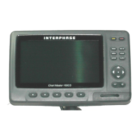
Describes the basic functions, features, and controls of the chart plotter.
Details the features and advancements of the C-MAP NT MAX cartography.
Explains the Global Positioning System and its operation with the chart plotter.
Guides on powering the unit on/off and adjusting screen brightness and contrast.
Covers selecting language, using C-Cards, and simulation mode for practice.
Explains how to change display modes and navigate the chart.
Details how to set a destination and initiate navigation.
Describes measuring distance/bearing and activating Man Overboard.
Explains creating, editing, and managing user-defined marks and waypoints.
Covers creating, selecting, and following navigation routes.
Describes setting destinations and recording vessel track logs.
Guides on configuring data windows and accessing object information.
Explains how to find and display port services and tide predictions.
Covers searching for ports, tide stations, wrecks, and other points of interest.
Describes setting up various audible and visual alarms for navigation.
Explains data backup and restore operations using the User C-CARD.
Details viewing external video input signals on specific models.
Covers settings for map layout, display, and system preferences.
Details customizing map display settings like marine, depth, and chart features.
Explains general display settings and unit selections.
Covers navigation-related settings and compass adjustments.
Configures GPS, autopilot, NMEA, and other external connections.
Explains the Automatic Identification System features and setup.
Details the weather forecasting system and data download options.
Describes how to access and use the Fish Finder and Radar functions.
Allows viewing software and cartography data details.
Details viewing external video input signals on specific models.
Explains the C-Link system for sharing cartographic data between plotters.
Details the transfer of navigation data between linked chart plotters.
Guides on performing system tests for troubleshooting and diagnostics.
Lists key features, technical specs, and C-Card procedures for V6/V6i models.
Covers mounting, dismounting, wiring, and typical connection diagrams.
Lists key features, technical specs, and C-Card procedures for 7MI/7CI/7MX/7CXS.
Covers mounting, dismounting, wiring, and typical connection diagrams.
Lists key features, technical specs, and C-Card procedures for 169CS/169CSI.
Covers mounting, dismounting, wiring, and typical connection diagrams.
Lists key features, specs, video input, and C-Card procedures.
Details cartography, operating temperature, memory, keyboard, and weight.
Explains C-Card procedures and shows physical dimensions.
Covers mounting, dismounting, wiring, and typical connection diagrams.
| Brand | Interphase |
|---|---|
| Model | Chart Master Chart Master 11 CVS+ |
| Category | GPS |
| Language | English |