Magellan MAP 410 GPS Receiver 15
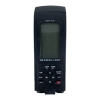
THE COMPASS SCREEN
As well as displaying four customizable navigation fields, the COMPASS
screen provides a pointer compass and Course Deviation Indicator (CDI) to
help you reach your destination.
The Course Direction icon displays your course over ground while the
Steering Indicator displays the bearing of the destination relative to the
course over ground. When the arrows are pointed in the same direction, you
are on course. The CDI indicates your distance left or right of the
courseline.
The NorthFinder ™ feature displays the position of the sun and moon icons,
when above the horizon, which allows you to determine the direction of
north and your destination. The destination icon shows the general direction
in which you should be travelling.
TO: HOME
E
N
W
S
DST
3.52
N
M
SOG
2.7
K
T
BRG
127
m
°
COG
156
m
°
1.0
M
I
Position Icon (Course
Direction Icon)
Destination
Name
Destination
Icon
Sun Icon
Steering Indicator
to Destination
Moon Icon
Compass
Course
Deviation Indicator
CDI Scale (L/R arrow
to change)