Do you have a question about the YUNEEC H850 and is the answer not in the manual?
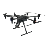
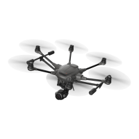
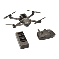
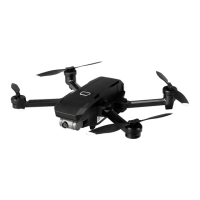
Details the components of the H850 drone with top and bottom views.
Provides a detailed illustration and labeling of the T-1 transmitter controls and ports.
Explains how to connect and charge the drone battery using the charge box.
Instructions for charging the T1 transmitter battery using a USB cable.
Step-by-step guide for attaching the drone's landing gear.
Instructions for unfolding and securing the drone's motor arms.
Guide on how to insert and secure flight batteries into the drone.
Describes the E90X camera's features, image capture, and video recording capabilities.
Explains how to use the digital zoom feature and its limitations.
Details the thermal imaging camera's combination of gimbals and measurement capabilities.
Describes the E30Zx camera's 30x zoom, sensor, and stabilization features.
Explains how to use the zoom in and zoom out functions for the E30Zx camera.
Recommendation for using a specific type of SD card for 4k video recording.
Step-by-step instructions for attaching the drone's gimbal.
Step-by-step instructions for detaching the drone's gimbal.
Procedures for powering the drone and transmitter on and off.
Situations suggesting recalibration of the drone's compass for flight safety.
Initial steps for compass calibration, including placement and sensor selection.
Detailed instructions for rotating the drone during compass calibration.
Instructions to reboot the drone after compass calibration is complete.
Connecting the T1 transmitter to the internet via Wi-Fi for network CORS.
Enabling RTK GPS functionality via the Vehicle settings.
Configuring the RTCM source to NTRIP and enabling auto-reconnect.
Inputting NTRIP stream settings according to CORS network requirements.
Finishing the CORS network connection process by tapping Apply.
Guidelines for operating the drone in open areas, avoiding obstructions.
Instruction to unfold propellers manually before starting motors.
Suggestion to use Angle Mode for taking off.
Information on antenna positioning for reliable signal transmission.
Steps for initiating takeoff using the transmitter's motor start and stick control.
How to use the app's Take Off icon and slide to confirm for takeoff.
Introduction to flight modes available on the transmitter.
Explanations of Angle, Sport, RTL, and Manual flight modes.
Steps to enable and configure the drone for indoor flight operations.
How to command the drone to fly to a specific point on the map.
Overview of the Orbit Flight settings and interface elements.
How to adjust orbit center, radius, speed, and altitude.
How to set a point of interest for the gimbal to track.
How to descend and land the drone using the throttle/altitude joystick.
Procedure for emergency motor stop using transmitter controls.
How to control the gimbal's tilt angle using the control knob.
How to control the gimbal's pan direction using the control knob.
Steps to re-bind the drone and transmitter if necessary.
Instructions for the binding process involving the drone and transmitter.
Steps for connecting the drone and completing the binding process.
Tapping the "Finish" button to complete the binding process.
Introduction to the DataPilot App's main interface and its components.
Explains flight mode and obstacle avoidance status indicators on the app.
Details communication status indicators and transmitter battery/RSSI display.
Explains drone GPS status and battery level indicators.
Information on Wi-Fi RSSI and accessing Wi-Fi settings.
How to select, refresh, connect, or reset Wi-Fi hotspots.
Overview of the flight control panel for quick commands before and after takeoff.
How to hide or adjust the size of the map thumbnail window.
Displays flight data like latitude, longitude, speed, and height.
Menu for adjusting camera parameters like exposure and white balance.
Displays gimbal tilt attitude and camera type/SD card capacity.
Controls for switching between photo and video modes, and capturing media.
How to preview, check, and delete photos/videos taken by the drone.
How to access the mission planning mode via the DataPilot App.
Defines a waypoint and its role in intelligent auto-functions during flight.
Steps for connecting to the internet, downloading maps, and setting takeoff points.
How to add waypoint positions on the map after setting the takeoff point.
Displays parameters for the currently selected waypoint in the mission.
Summary of the flight mission and display of the flight route.
Panel for adjusting altitude, speed, hold time, gimbal, and camera settings.
How to configure camera behavior and modes for each waypoint.
Setting the camera's pitch and yaw angles for each waypoint.
Options to move waypoints to the vehicle's position or previous item.
Menu for precise adjustment of waypoint coordinates using various systems.
How to select survey mode and initiate mission setup.
Further settings for the survey mission, including takeoff and altitude.
Describes using the basic rectangular survey area template.
Describes using the circular survey area template.
Describes using the trace template for setting survey area vertices.
Using polygon tools to define the survey area shape.
Adjusting survey parameters after confirming the survey area.
Setting front and side overlap percentages for image capture.
Setting flight altitude or ground resolution for survey tasks.
Adjusting the angle of survey grid lines and turnaround distance.
Changing the drone's entry and exit points for the survey area.
Settings like hover capture, refly at 90 degrees, and images in turnarounds.
Enabling vehicle to follow terrain for closer ground capture.
Importance of selecting the correct camera for accurate survey results.
How to save, load, and delete survey settings as presets.
Saving and applying presets for corridor scan missions.
Illustrates an example of a corridor scan mission setup.
Steps to create a corridor scan using the DataPilot App.
Overview of the two preset templates for editing corridor scan areas.
Explains how to use basic and trace templates for corridor scans.
Adjusting scan parameters like overlap, altitude, and corridor width.
Importance of camera selection for accurate corridor scan results.
Explains structure scans for vertical surfaces and 3D modeling.
How to insert and set up a structure scan mission.
Overview of basic, circular, and trace templates for structure scans.
Adjusting scan parameters like overlap, scan distance, and structure height.
Importance of camera selection for accurate structure scan results.
Options for creating, saving, uploading, and clearing flight plans.
How to add and manage Region of Interest points for camera tracking.
Using the coaching function to capture drone GPS positions as waypoints.
Steps to upload and execute a created flight mission.
Methods to pause the drone's mission flight.
How to continue a paused mission or set a new altitude.
Procedures for landing or returning the drone during a mission.
How to resume an unfinished mission after battery change or landing.
Steps to continue a mission after powering off and changing the battery.
Overview of the settings interface for adjusting parameters.
Options for language, color scheme, map provider, and default mission altitude.
Changing map provider and type based on network conditions.
Managing offline maps for field operation without internet connectivity.
How to delete the default offline map tile set.
Editing and saving new offline map tile sets.
Selecting map provider, type, and zoom levels for offline maps.
Reviewing, deleting, renaming, and confirming added offline map tile sets.
Importing and exporting downloaded map tile sets between devices.
Instructions for importing and exporting map tile sets.
Checking the firmware versions of the drone's components.
Connecting the drone system to a CORS source for RTK positioning.
Monitoring the controller's hardware input (joysticks, knobs, buttons).
Procedure for calibrating the T1 transmitter's joysticks and knobs.
Steps to perform the switch calibration on the transmitter.
Completing the RC calibration by tapping OK after the process.
Options to reset parameters, control motor LEDs, enable indoor mode, and RTK GPS.
How to reset all vehicle parameters to their default values.
Rebooting the drone to apply parameter changes after reset.
Controlling the motor LEDs for photography or visual indication.
Checking product type, vehicle ID, and HOBBS meter information.
Displays a summary of the vehicle's current settings and sensor status.
Selecting the desired joystick mode (Mode 1-4) for drone control.
Verifying the status of sensors like Compass, Gyro, and Accelerometer.
Configuring drone fail-safe behavior and geo-fence parameters.
Setting failsafe actions for RC or data link loss.
Configuring geo-fence radius, altitude, and breach behavior.
Defining drone behavior (None, Warning, Hold, Return) when breaching geo-fence.
Configuring climb altitude, return point, and velocity settings for Return Home.
Setting maximum climb, descent, and horizontal velocities for flight.
Technical specifications for the T1 Transmitter.
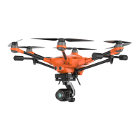
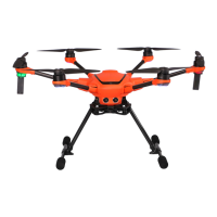
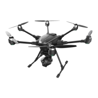
Technical specifications for the H850 drone, including weight, dimensions, and performance.
Overview of LED indicators for various operational statuses.
Details Yuneec's liability limitations in various circumstances.
Information on Yuneec's collection and processing of user data.
Critical warnings and guidelines for Li-ion battery handling and usage.
Detailed safety precautions for charging, storing, and using Li-ion batteries.
Essential safety guidelines for operating the drone and its components.
Information on FCC rules, interference, and compliance conditions.
Warning regarding RF exposure and antenna installation requirements.
EU requirements for limiting public exposure to electromagnetic fields.
Declaration of conformity with EU RED Directive 2014/53/EU.
Information on downloading the latest content and contacting support.