Do you have a question about the Furuno FMD-3200 and is the answer not in the manual?
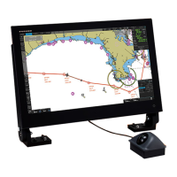
Overview of the ECDIS system.
Potentially hazardous situations that could result in death or serious injury if not avoided.
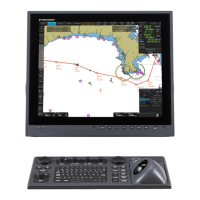
Details of the Processor Unit, the core of the ECDIS system.
Procedure for powering the system on and off.
Description of the controls and functions of the RCU-024.
Instructions for adjusting monitor brightness and control unit backlighting.
Procedure for selecting navigation sensor inputs (System or Local).
Methods for entering ship speed data (STW or SOG).
Procedure for entering ship's heading manually or automatically.
Description of the ECDIS screen layout and its various areas.
Explanation of the InstantAccess bar functions and modes.
Details on displaying ship's heading, speed, course, and position.
Methods for changing the chart scale and understanding related messages.
Instructions for managing routes and user charts in navigation and planning modes.
Guidance on using Variable Range Marker (VRM) and Electronic Bearing Line (EBL).
Procedures for preparing the system before a voyage.
Procedure for installing public keys to authenticate ENC chart materials.
Steps for installing ENC licenses and chart data.
Procedure for installing ARCS licenses and chart data.
Instructions for installing C-MAP database and licenses.
Guidance on installing C-MAP Dynamic Licensing charts.
Procedure for backing up and restoring chart licenses.
Viewing graphical coverage and status of stored chart cells.
Manual update procedures for ENC and C-MAP charts.
Steps for synchronizing chart data between multiple units.
Controlling the display of chart features via menus.
Managing the display of symbols and features through the Symbol Display menu.
Settings for displaying TT and AIS target information.
Managing date-dependent features and setting display dates.
Introduction to ARCS charts, their availability and update process.
Procedure for registering the system with C-MAP for eToken authentication.
Information on C-MAP Dynamic Licensing for immediate ENC access.
Overview of chart alerts and how to set the safety contour.
Procedure for activating own ship check and setting alert areas.
Definition of a route plan and its main functions.
Step-by-step instructions for creating a new route with waypoints.
Procedures for changing waypoint positions and other data.
Explanation of available route optimization strategies.
Methods for importing route data from other units or formats.
Common faults and their remedies for restoring normal operation.
| Display Type | LCD |
|---|---|
| Power Supply | 24 VDC |
| Operating Temperature | -15°C to +55°C |
| ECDIS | Yes |
| Waterproof Standard | IP22 |
| Interfaces | USB |
| Chart Format | S-57, S-63 |
| Weight | Approx. 9.5 kg |