Navigation
190-02488-01 Rev. B Pilot’s Guide 3-11
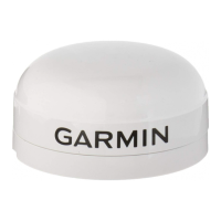
Track Vector
FEATURE LIMITATIONS
• Indication absent when aircraft velocity is < 30 kt
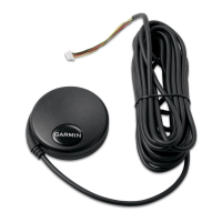
Ahead View
FEATURE LIMITATIONS
• Not available when page orientation is North Up
Track vector length options display as a dashed line and arrow extending from
the aircraft icon, showing current track and distance the aircraft will travel in the
selected time.
If the track vector is placed over a point on the map, and no data is entered into
the system, the unit indicates a wind-corrected GPS track to that point. This is
useful for intercepting airways and radials, making small but positive lateral
corrections during approaches, and in setting up for arrivals in the terminal area.
Indicates the current ground track.
Arrow tip represents aircraft position
at the specified time interval
(if the aircraft maintains current
ground track during that time).
Repositions ownship near the
bottom of the page to expand the
view ahead.
 Loading...