EasyManuals Logo

Garmin GPS 175 User Manual

Garmin GPS 175
290 pages
To Next Page IconTo Next Page
To Previous Page IconTo Previous Page
Page #245 background imageLoading...
Page #245 background image
Hazard Awareness
190-02488-01 Rev. B Pilot’s Guide 5-41
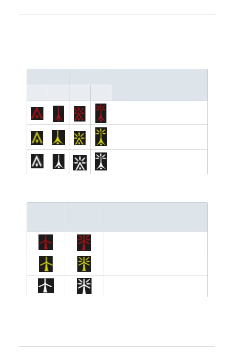
Obstacle Elevation Depictions
FEATURE LIMITATIONS
Obstacles more than 2,000 ft below current altitude do not display
TOWER OBSTACLES
WIND TURBINE OBSTACLES
UNLIGHTED
OBSTACLE
LIGHTED
OBSTACLE
OBSTACLE LOCATION
<1000’
AGL
>1000’
AGL
<1000’
AGL
>1000’
AGL
Red obstacle is above or within 100 ft
below current altitude.
Yellow obstacle is between 100 ft and
1000 ft below current altitude.
White obstacle is between 1,000 ft and
2,000 ft below current altitude.
UNLIGHTED
WIND
TURBINE
OBSTACLE
LIGHTED
WIND
TURBINE
OBSTACLE
OBSTACLE LOCATION
Red obstacle is above or within 100 ft
below current altitude.
Yellow obstacle is between 100 ft and
1,000 ft below current altitude.
White obstacle is between 1,000 ft and
2,000 ft below current altitude.

Table of Contents

Other manuals for Garmin GPS 175

Questions and Answers:

Question and Answer IconNeed help?

Do you have a question about the Garmin GPS 175 and is the answer not in the manual?

Garmin GPS 175 Specifications

General IconGeneral
Display Resolution480 x 272 pixels
GPS ReceiverWAAS GPS
Receiver TypeGPS/WAAS
Display TypeColor TFT
MountingPanel mount
InterfacesRS-232, ARINC 429
Operating Temperature-20°C to +55°C
TypeAviation GPS Navigator
InterfaceRS-232
DatabaseObstacle, Terrain
CompatibilityCompatible with select autopilots

Related product manuals