EasyManuals Logo

Garmin GPS 175 User Manual

Garmin GPS 175
290 pages
To Next Page IconTo Next Page
To Previous Page IconTo Previous Page
Page #126 background imageLoading...
Page #126 background image
3-24 Pilot’s Guide 190-02488-01 Rev. B
Navigation
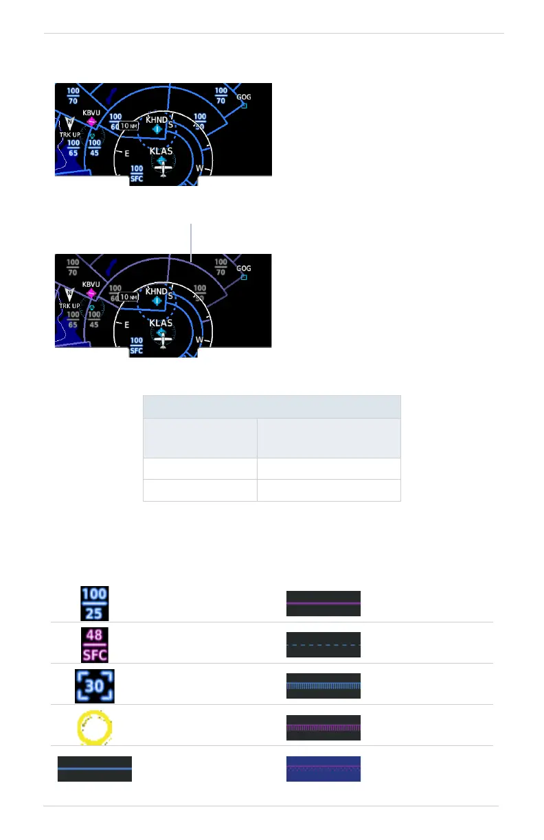
Smart Airspace
[1] Vertical distance above and below aircraft altitude.
AIRSPACE DATA SYMBOLS
SMART AIRSPACE CRITERIA
AIRCRAFT
ALTITUDE
AIRSPACE PROXIMITY
TO AIRCRAFT
[1]
Sea level >1,000 ft
>10,000 ft 2,000 ft
Class B Altitude
Label (ceiling/floor)
Class C/TCA
Class C Altitude
Label (ceiling/floor)
Class D
Class D Altitude
Label (ceiling only)
Restricted/Prohibited
TFR MIL
Class B/TMA Other/ADIZ
Garmin’s Smart Airspace feature
automatically de-emphasizes
non-pertinent airspace away from
the aircraft’s current altitude.
When an airspace’s vertical
proximity to the aircraft is
>1,000 ft:
Its boundary becomes
transparent
All associated altitude labels
turn gray
This range increases linearly to
2,000 ft as the aircraft ascends
to 10,000 ft.
Smart Airspace Off
Smart Airspace On
Non-pertinent
Airspace

Table of Contents

Other manuals for Garmin GPS 175

Questions and Answers:

Question and Answer IconNeed help?

Do you have a question about the Garmin GPS 175 and is the answer not in the manual?

Garmin GPS 175 Specifications

General IconGeneral
Display Resolution480 x 272 pixels
GPS ReceiverWAAS GPS
Receiver TypeGPS/WAAS
Display TypeColor TFT
MountingPanel mount
InterfacesRS-232, ARINC 429
Operating Temperature-20°C to +55°C
TypeAviation GPS Navigator
InterfaceRS-232
DatabaseObstacle, Terrain
CompatibilityCompatible with select autopilots

Related product manuals