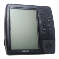
Do you have a question about the Garmin GPSMAP 296 and is the answer not in the manual?
Explains how to charge the unit's battery and details Charge Mode functionality.
Details the process for powering the unit on/off and adjusting backlight and volume.
Explains how the unit acquires satellite signals and how to view GPS status.
Explains the function of each key on the GPSMAP 296 keypad for user navigation.
Provides guidance on navigating menus, selecting options, and entering data using the unit's interface.
Provides instructions on setting a destination and creating a direct course in Aviation Mode.
Guides users on locating nearby airports, weather sources, and other points of interest.
Guides users on selecting an approach procedure for a destination airport.
Instructions on how to mark and save the current or selected location as a waypoint.
Guides users through creating and saving flight plans or routes with multiple waypoints.
Explains how the GPSMAP 296 guides you to your destination using created flight plans.
Provides an overhead view of terrain and obstacles, with color-coded alerts for proximity.
Displays GPS-derived data graphically, including HSI, ground speed, and altitude.
Explains the Vertical Navigation feature for guiding altitude and descent profiles.
Shows each point of an active route, including name, course, distance, and ETA.
Provides calculations for Density Altitude, True Airspeed, and Winds Aloft using entered data.
Explains how to start navigation to a point using map items or the Find menu.
Covers viewing saved routes, starting routes, and manually transitioning between waypoints.
Explains the Map Page in Marine Mode, its location marker, zoom, and data fields.
| Display Resolution | 480 x 320 pixels |
|---|---|
| Display Type | Color TFT |
| Battery | Rechargeable Lithium-ion |
| Water Resistance | IPX7 |
| Basemap | Yes |
| Waypoints | 3000 |
| Routes | 50 |
| Track Log | 10, 000 points |
| Display Size | 3.8 inches |
| GPS Receiver | WAAS enabled |
