Do you have a question about the Garmin OVERLANDER and is the answer not in the manual?
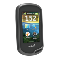
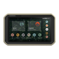
Identifies and explains the physical components of the navigation device.
Instructions for attaching the ball mount adapter to the device for vehicle mounting.
Procedures for powering the device on, off, or into power saving mode.
Explains how the device obtains satellite signals for location services.
Explains the layout and interactive elements of the device's home screen.
How to launch applications and add shortcuts to the home screen.
Understanding notifications, status bar icons, and basic touchscreen gestures.
How to manually or automatically adjust the display brightness levels.
Step-by-step guides for managing vehicle profiles.
Information on driver alerts, speed limits, and camera notifications.
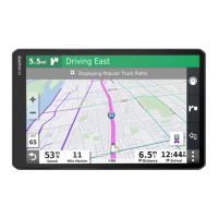
How to start a route, use the map, and navigate home.
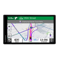
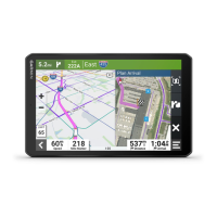
Explains the on-screen map display during navigation.
Visual lane guidance and viewing upcoming turns and directions.
Device assistance for completing and ending navigation to a destination.
Finding parking, adding intermediate destinations, and manually adjusting routes.
Taking detours, changing route calculation, and avoiding traffic delays.
Avoiding tolls, road features, and environmental zones.
Defining specific roads or areas to avoid on your routes.
Browsing and searching pre-loaded points of interest by category.
Searching for locations using categories and subcategories.
Finding campsites, motor home parks, and services.
Finding national parks and iOverlander points of interest for overlanding.
Accessing historical points of interest and Foursquare locations.
Finding TripAdvisor POIs, navigating within venues, and exploring venue features.
Using the search bar and address search for locating places.
Understanding the format and options for displaying search results.
Viewing search results directly on the map interface.
Changing search area, custom POIs, and installing POI Loader.
Finding parking, junctions, locations by coordinates, and viewing history.
Accessing detailed current location data, vital for emergency situations.
Finding emergency services and getting directions to your current location.
Creating shortcuts and saving current or found locations.
Modifying, organizing, and removing saved favorite locations.
Navigating and interacting with the map in street view.
Overview of map tools like Traffic, Turns, and Trip Data.
Displaying upcoming locations, exits, and services along the route.
Customizing Up Ahead categories and understanding warning symbols.
Explains symbols for vehicle restrictions and road conditions.
Viewing, customizing, and resetting trip data and logs.
Checking for and viewing traffic incidents along the route.
Viewing traffic on map and searching for incidents.
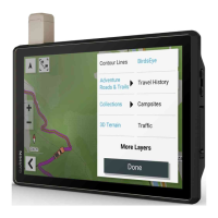
Customizing map layers, data fields, and perspective.
Introduction to the Garmin Explore app for planning and syncing off-road trips.
Logging into Garmin Explore and downloading offline maps.
Updating Garmin Explore maps and filtering map data.
How to create and save waypoints using the Garmin Explore app.
Creating routes and accessing saved items in the Garmin Explore library.
Syncing Explore data and importing/exporting GPX files via memory card.
Recording travel tracks and adjusting tracking intervals.
Calibrating and adjusting pitch/roll sensors and alerts.
Accessing data from the Altimeter, Barometer, and Compass sensors.
Manual calibration procedure for the electronic compass.
Connecting, sending messages, and initiating SOS with an inReach device.
Initiating and cancelling emergency SOS rescues via inReach.
Pairing a mobile phone for Bluetooth hands-free calling.
Bluetooth pairing advice, making calls, and receiving calls.
Using in-call options and setting up speed dial presets.
Disconnecting and deleting paired Bluetooth devices.
Enabling the traffic feature by connecting a traffic receiver.
Displaying traffic on map and searching for incidents.
Setting up and activating the voice command feature.
Navigating via voice command and overview of device apps.
Using the Fusion-Link app to control a compatible Fusion stereo.
Connecting stereo via Wi-Fi and basic music playback controls.
Choosing audio sources and using playback controls for music.
Adjusting volume, muting, and tone settings for speaker zones.
Configuring speaker zones, including naming, linking, and disabling.
Adjusting subwoofer filters and configuring DSP settings for audio optimisation.
Saving, selecting, and removing radio station presets.
Configuring speaker zone names, linking, disabling, and internal amplifiers.
Adjusting sound, location services, language, date/time, and system settings.
Resetting settings to defaults and viewing device regulatory information and specifications.
Methods for charging the battery and general device care.
Information on obtaining help, manuals, and FAQs from Garmin.
Procedure for updating device maps and software wirelessly.
Using Garmin Express software for device updates.
Guidelines for cleaning the device and preventing theft.
Changing the vehicle power cable fuse and resetting the device.
Steps to detach the device, mount, and suction cup from the vehicle.
Solutions for a loose suction cup or unstable mount.
Troubleshooting GPS signal acquisition, charging, and Bluetooth phone connection.
Important factors for mounting the Garmin PowerSwitch device.
Step-by-step guide for installing the PowerSwitch device.
Instructions for opening the PowerSwitch front cover to access connections.
Guidelines for connecting accessories to the Garmin PowerSwitch device.
Connecting control sources for custom PowerSwitch outputs.
Steps to connect the PowerSwitch device to the vehicle's electrical system.
How to pair the PowerSwitch with a compatible Garmin navigation device.
Troubleshooting PowerSwitch connection loss and accessory power problems.
Steps to pair a BC 35 backup camera with the navigation device.
How to view and switch between backup camera feeds.
Adjusting camera orientation and connecting to a wireless display.
Installing and formatting memory cards for storage.
Connecting the device to a computer and transferring files.
Information on buying additional maps and accessories for the device.
| Widescreen | - |
|---|---|
| Display diagonal | 7 \ |
| Touch technology | Multi-touch |
| Display resolution | 1024 x 600 pixels |
| Battery type | Built-in |
| Battery life (max) | 3 h |
| Number of batteries supported | 1 |
| Form factor | Fixed |
| Product color | Black |
| International Protection (IP) code | IP5X |
| Storage media type | Flash |
| Compatible memory cards | MicroSD (TransFlash) |
| Internal storage capacity | 64 GB |
| Marine (chartplotters, sounders) | No |
| Operating temperature (T-T) | -20 - 55 °C |
| Headphone connectivity | 3.5 mm |
| Lifetime map updates | Roads change, but with Lifetime Map Updates your map will always be up to date. Start fresh every few months by downloading a new edition of the industry's most accurate map. New editions are issued four times per year. |
| Cables included | USB |
| Depth | 24 mm |
|---|---|
| Width | 199 mm |
| Height | 122 mm |
| Weight | 437 g |