Do you have a question about the Magellan ProMark 3 and is the answer not in the manual?
Provides an introduction and initial setup for the ProMark3 and ProMark3 RTK systems.
Covers copyright, trademarks, FCC, CE, and RSS-210 regulatory information.
Details the limited warranty terms and conditions for Magellan products.
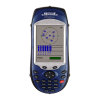
Explains the basic functionality and features of the ProMark3 data collector.
Describes the enhanced capabilities of the ProMark3 RTK for real-time surveys.
Provides an overview of the key hardware components included with the ProMark3.
Details the physical keyboard, stylus interaction, and on-screen keypad.
Instructions for charging the device's rechargeable battery pack.
Guides the user on how to power the receiver on and off.
Covers screen calibration, time updates, and backlight adjustments.
How to access preliminary settings and select storage media (internal/SD card).
Setting the receiver ID and defining the external antenna parameters.
Selecting preferred units for distance, speed, and area measurements.
Explains the principles of RTK and its requirements for centimeter accuracy.
Details the base/rover and network connection RTK configurations.
Describes various methods for initializing the rover for RTK surveys.
Instructions for setting up the rover using NTRIP or Direct IP via a cell phone.
Procedure for logging individual points during a real-time survey.
Procedure for logging continuous survey trajectories.
Steps to create a new job and configure its basic settings in FAST Survey.
Setting up the base and rover configurations within the FAST Survey software.
Procedures for initializing the rover using FAST Survey methods.
How to log individual RTK points using the FAST Survey software.
Instructions for logging RTK points continuously with FAST Survey.
Guide for performing stakeout operations using FAST Survey.
Details on performing static surveys for post-processing.
Instructions for conducting "Stop & Go" surveys for post-processing.
Procedures for kinematic surveys used in post-processing.
Explains initialization methods relevant to post-processing techniques.
Steps for setting up the equipment for a static survey.
Configuration details for performing a static survey.
Procedure for collecting data during a static survey.
Instructions for setting up the base station for a Stop & Go survey.
Instructions for setting up the rover for a Stop & Go survey.
Configuration details for the rover in a Stop & Go survey.
Steps for initializing the rover during a Stop & Go survey.
Procedure for collecting data at points during a Stop & Go survey.
Instructions for setting up the base station for a kinematic survey.
Instructions for setting up the rover for a kinematic survey.
Configuration details for the rover in a kinematic survey.
Steps for initializing the rover during a kinematic survey.
Initial setup and considerations before starting mobile mapping.
Procedure for creating jobs and logging point features in mobile mapping.
How to log line features, including defining logging intervals.
How to log area features, including defining logging intervals.
Steps to revisit and update existing GPS/GIS job data.
How to reposition point features and add new features to existing jobs.
Procedure for closing a GPS/GIS job after updates.
General procedures for downloading data from the ProMark3 to a PC.
Specific steps for downloading raw data collected using the Surveying application.
Instructions for downloading RTK data collected from the receiver.
Steps for importing and processing raw survey data using GNSS Solutions.
Procedure for downloading RTK data collected via FAST Survey.
Guide on exporting processed field data into a GIS database.
How to use the NAV key to cycle through and utilize navigation screens.
Customizing the device by disabling unused navigation screens.
Information on Bluetooth management and unlocking RTK/FAST Survey features.
Details on how FAST Survey reassigns device function keys.
| Operating Temperature | -20° C to +60° C |
|---|---|
| Humidity | 95% non-condensing |
| Bluetooth | Yes |
| Waterproof | IP67 |
| Frequency | L1, L2 |
| Accuracy (RTK) | 10 mm + 1 ppm (Horizontal), 15 mm + 1 ppm (Vertical) |
| Time to First Fix (Hot Start) | 10 s |
| Vibration | MIL-STD-810G |
| Battery Type | Rechargeable Li-ion |
| Data Storage | Internal memory |
| Communication | Bluetooth, USB |
| Battery Life | >10 hours |