6
1. General Description
1.1 Overview
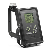
The PI-4100 is Potomac Instruments’ third generation of precision survey instrumentation
designed specifically for the direct measurement of electromagnetic field strength in the 200 kHz to 5.1
MHz frequency spectrum. This microcontroller driven instrument combines a laboratory quality
measuring receiver, a balanced loop antenna, an internal GPS receiver, an internal calibration source, data
acquisition hardware and software, and a graphical LCD display in a single rugged package weighing less
than 3 kg. The device measures, displays, and at the option of the operator, records the following:
Field Strength. This instrument measures and indicates electromagnetic field strength in the 200 kHz to
5.1 MHz spectrum at levels ranging from 30 µV/m (29.5 dBuV/M) to above 50 V/m (154 dBuv/M).
Date & Time of measurement. For logging the PI 4100 indicates date and coordinated universal time
(UTC) derived from the Global Positioning Satellite (GPS) constellation. For users preferring to
record data in local time, the operator has the option of offsetting UTC time via menu selection.
Distance from the transmitting antenna or array. Line-of-sight distance from the point of
measurement to the transmitting source is displayed both for operator feedback and for logging. This
feature is enabled when the latitude and longitude coordinates of the source are entered into PI 4100
memory by the operator.
Magnetic bearing from the measuring point to the
transmitting antenna or array.
The PI 4100 indicates Magnetic Bearing (True Bearing ± Declination) to the source if the latitude and
longitude and magnetic declination for the source has been entered into memory.
True azimuth (radial) from the source to the measuring point. Conventional use of Field Strength
data often requires the data to be presented as a plot, on polar graph (or map), referenced to True
North. The PI 4100 employs its internal GPS receiver to calculate and display the True azimuth, in
degrees, from the sourceto the measuring point both for operator reference and logging purposes.
Geographical coordinates of the measuring point. The PI 4100 internal GPS captures and displays the
Latitude and Longitude of the physical location from which a given measurement is conducted
(degrees, minutes, and seconds). This information can be stored with other pertinent data for future
retrieval.
Spectrum occupancy (visual display) for the RF spectrum immediately adjacent to the measured
frequency. The spectrum display screen provides 1.0 kHz resolution bandwidth and a sweep width
of either ±22 kHz or ±64 kHz from center. Amplitude resolution on-screen is 1.0 dB. Carrier
frequency is displayed (center screen) and an internal Marker can be moved in increments of 1.0 kHz
either side of the carrier to precisely measure frequency response or interference level (in dB below
carrier with 0.1 dB resolution) at the Marker frequency.
Functional elements: The PI 4100 Functional Block Diagram, Fig. 1, p. 10, shows the PI 4100's
functional elements.