Do you have a question about the TOKNAV T10Pro and is the answer not in the manual?
Safety precautions and warnings for using the product.
Disclaimers for damages and lost profits due to misuse or other factors.
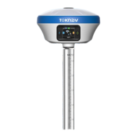
Description and illustration of the T10Pro's physical components and ports.
How to check the device's battery level using the indicator light.
Instructions for turning the device on, off, and performing a forced shutdown.
Step-by-step guide to inserting a SIM card into the device.
Information on charging the device using a Type-C charger and indicator lights.
Instructions for installing the radio antenna when datalink is set to internal radio.
Overview of the device's status including GNSS, Register Info, and Working Mode.
How to view device information and perform firmware upgrades for the positioning board and modules.
Displays satellite skyplot and GNSS system configuration options like Elev Cutoff.
Used to debug data information and view current data status, with options for data types.
Allows configuration of working modes like Rover, Base, and Static, including parameters like Elev Cutoff.
Settings for GNSS System, WiFi modes (Disable/AP/Station), and other options like Time Zone and Voice.
File management for downloading and deleting data in batches.
Provides download of operation logs for troubleshooting device abnormalities.
Configuration of text data output format and frequency, with examples of common message texts.
Enables virtual LAN and remote technical support via WebUI access after inserting a mobile network card.
Configuration for saving various files across five channels, including data source, period, and format.
Introduces the PCR100 TD-LTE wireless computer and its key features for survey tasks.
Describes how to establish communication between the device and other systems, primarily via Bluetooth.
Steps to create a new project, including setting coordinate system parameters and project details.
Instructions for copying and importing data files into the device's internal storage.
Steps for exporting data files from the device, including selecting format and path.
Configuration for four-parameter conversion, used for specific survey work or when base station position changes.
Setting basic parameters for Rover Mode, such as cut-off angle, differential delay, and data link selection.
Configuration for Base Mode, including setting Base ID, differential mode, PDOP limit, and data link.
Options for Static Mode, including point name, PDOP limit, altitude cut-off, and data acquisition parameters.
Guide to opening the point survey page and viewing device status, positioning accuracy, and collecting data.
Functionality and calibration process for tilt survey, ensuring accuracy within 2cm up to 60° inclination.
Process for activating the device by checking and inputting a valid registration code.
Procedure for checking software expiration and activating it with a new code.
| Type | GNSS Receiver |
|---|---|
| Operating Temperature | -40°C to 65°C |
| Storage Temperature | -40°C to 85°C |
| Tilt Sensor | Support |
| Electronic Bubble | Support |
| IMU | Support |
| Data Format | CMR, RTCM3.2 |
| Data Output | NMEA-0183 |