Do you have a question about the TOKNAV T20Pro and is the answer not in the manual?
Read safety precautions carefully before using the product to ensure the safety of operators and others.
Disclaims liability for damages and lost profits resulting from misuse or natural disasters.
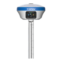
Details the physical components and design of the T20Pro GNSS receiver.
Explains the display screen and the information it shows, including mode and status.
Provides instructions for powering the device on, shutting it down, and performing a forced shutdown.
Guides on how to insert a SIM card for network working mode and enabling network functions.
Details the process and requirements for charging the device's battery using a Type-C charger.
Instructions on how to attach the radio antenna when the datalink is set to internal radio.
Lists all accessories and equipment included in the package for user verification.
Displays overall system status, including GNSS status and registration information.
Information about device firmware, including version details and upgrade procedures.
Visualizes satellite skyplot data, showing satellite positions and signal quality.
Enables viewing and debugging of data streams, including message text and raw data.
Configuration options for different operating modes like Rover, Base, and Static.
Settings for miscellaneous configurations like Time Zone, Voice, and Wi-Fi.
Manages device files, allowing download and deletion of data batches.
Provides access to download operation logs for troubleshooting device anomalies.
Configuration and display of various text-based data messages from the device.
Enables remote technical support and services through a virtual LAN connection.
Configures data storage channels, file period, name, and format for saving data.
Details the DP0031 TD-LTE wireless computer, its features, and rugged design for field use.
Explains how to establish and manage communication connections, primarily via Bluetooth.
Guides on creating a new project, setting coordinate systems, and defining project parameters.
Instructions for importing data files into the device's internal storage.
Details the process of confirming export path, file name, and data format for exporting data files.
Explains the process of localizing the device, particularly for specific survey work in China.
Configures the device for Rover mode, including cut-off angle, data link, and connection settings.
Configures the device for Base mode, including base ID, differential mode, and PDOP limit.
Sets options for static mode, including point name, PDOP limit, and observation time.
Displays current device status, coordinates, and antenna parameters for point surveying.
Enables tilt survey function, allowing accurate measurements within a 60° inclination range.
Confirms device registration code validity and guides on registering the device if expired.
Checks software expiration and guides on activating the software with a new code.
| Acquisition Sensitivity | -148dBm |
|---|---|
| Accuracy | 2.5m |
| Interface | UART |
| Protocol | NMEA-0183 |
| Operating Temperature | -40°C to +85°C |