6
DJI Terra supports exporting point cloud models and trajectory
files in the following formats:
Point cloud format: PNTS/LAS/PLY/PCD/S3MB
Trajectory file format: sbet.out/sbet.txt
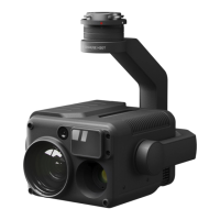
[1] Measured using a flat subject with a size larger than the laser beam diameter, a perpendicular angle of incidence,
and an atmospheric visibility of 23 km. In low-light environments, the laser beams can achieve the optimal detection
range. If a laser beam hits more than one subject, the total laser transmitter power is split, and the achievable range
is reduced. The maximum detection range is 500 m.
[2] Measured under the following conditions in a DJI laboratory environment: Zenmuse L2 was mounted on Matrice
350 RTK and powered on. In DJI Pilot 2, the Area Route mode was used to plan the route (with IMU Calibration
enabled), repetitive scanning was used, and the RTK status was set to FIX. The relative altitude was set to 150 m,
flight speed to 15 m/s, and gimbal tilt to -90°, and each straight segment of the route was no more than 1500 m. The
field contained objects with obvious angular features, and exposed hard-ground checkpoints that conformed to the
diffuse reflection model were used. DJI Terra was used for post-processing with Optimize Point Cloud Accuracy
enabled. Under the same conditions with Optimize Point Cloud Accuracy disabled, the vertical accuracy is 4 cm and
the horizontal accuracy is 8 cm.
[3] Measured in an environment of 25° C (77° F) with a subject of 80% reflectivity at a distance of 150 m. The actual
environment may differ from the testing environment. The result listed is for reference only.
[4] Measured under the following conditions in a DJI laboratory environment: Zenmuse L2 was mounted on Matrice
350 RTK and powered on. In DJI Pilot 2, the Area Route mode was used to plan the route (with IMU Calibration
enabled) and the RTK status was set to FIX. The mission height was set to 150 m, flight speed to 15 m/s, and gimbal
tilt to -90°, and each straight segment of the route was no more than 1500 m.
[5] Zenmuse L2 supports the Security Code function. Users can go to Data and Privacy in DJI Pilot 2 and set a
security code to encrypt microSD cards inserted into payloads. DJI Decrypt Tool can be downloaded from the DJI
official website to decrypt the microSD cards on a Windows computer and access the microSD card content.
 Loading...