26 eTrex Legend H and eTrex Vista H Owner’s Manual
Basic Operation
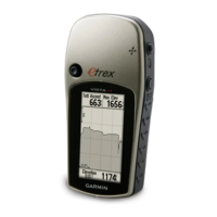
Track Proles
A Track Elevation Prole is
created from elevation readings
when using the eTrex Vista H.
Both the Vista H and Legend H
show proles, if using Digital
Elevation Model (DEM) maps.
Refer to the Garmin Web site for
information about these maps.
To view a track prole:
1. Open the Saved Track page,
and press MENU.
2. Select Prole. The beginning
of the track is marked by a
ag. Use the ROCKER to
scroll across the track prole.
At any point along the prole,
press the ROCKER to show it
on the map.
3. Press
MENU to use Zoom
Ranges and Hide Symbols
options.
Navigating a Saved
Track
To use the TracBack
®
feature:
1. With the Saved Tracks page
for the track or the Track Log
open, select TracBack, to
show the track. Select the
point to TracBack.
2. Use the ROCKER to move
the pointer to the point on the
map to start navigating the
TracBack.
3. Move in the direction of the
rst turn. At the rst turn,
directions to each turn are
shown.
 Loading...