190-00870-02 Rev. A
Garmin G950 Pilot’s Guide for the Pilatus PC-6
297
HAZARD AVOIDANCE
SYSTEM
OVERVIEW
FLIGHT
INSTRUMENTS
EIS
AUDIO PANEL
& CNS
FLIGHT
MANAGEMENT
HAZARD
AVOIDANCE
AFCS
ADDITIONAL
FEATURES
APPENDICES INDEX
thunDerstorMs
Updrafts and downdrafts in thunderstorms carry water through the cloud. The more severe the drafts, the
greater the number and size of the precipitation droplets. With this in mind, the following interpretations
can be made from what is displayed on the weather radar. Avoid these areas by an extra wide margin.
• In areas where the displayed target intensity is red or magenta (indicating large amounts of precipitation),
the turbulence is considered severe.
• Areas that show steep color gradients (intense color changes) over thin bands or short distances suggest
irregular rainfall rate and strong turbulence.
• Areas that show red or magenta are associated with hail or turbulence, as well as heavy precipitation. Vertical
scanning and antenna tilt management may be necessary to identify areas of maximum intensity.
Along squall lines (multiple cells or clusters of cells in a line) individual cells may be in different stages
of development. Areas between closely spaced, intense targets may contain developing clouds not having
enough moisture to produce a return. However, these areas could have strong updrafts or downdrafts.
Targets showing wide areas of green are generally precipitation without severe turbulence.
Irregularities in the target return may also indicate turbulence, appearing as hooks, fingers, or scalloped
edges. These irregularities may be present in green areas with no yellow, red, or magenta areas and should
be treated as highly dangerous areas. Avoid these areas as if they are red or magenta.
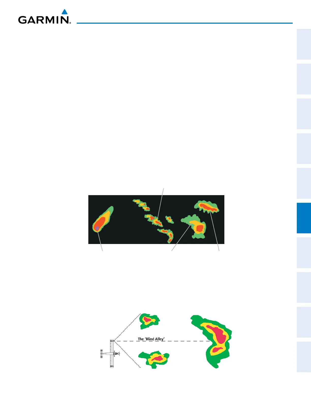
Figure 6-7 Cell Irregularities
Steep Gradient
Squall Line
Hook or Finger
Scalloped Edge
Thunderstorm development is rapid. A course may become blocked within a short time. When displaying
shorter ranges, periodically select a longer range to see if problems are developing further out. That can
help prevent getting trapped in a blind alley or an area that is closed at one end by convective weather.
Figure 6-8 The Blind Alley - Horizontal Scan