190-00870-02 Rev. A
Garmin G950 Pilot’s Guide for the Pilatus PC-6
341
HAZARD AVOIDANCE
SYSTEM
OVERVIEW
FLIGHT
INSTRUMENTS
EIS
AUDIO PANEL
& CNS
FLIGHT
MANAGEMENT
HAZARD
AVOIDANCE
AFCS
ADDITIONAL
FEATURES
APPENDICES INDEX
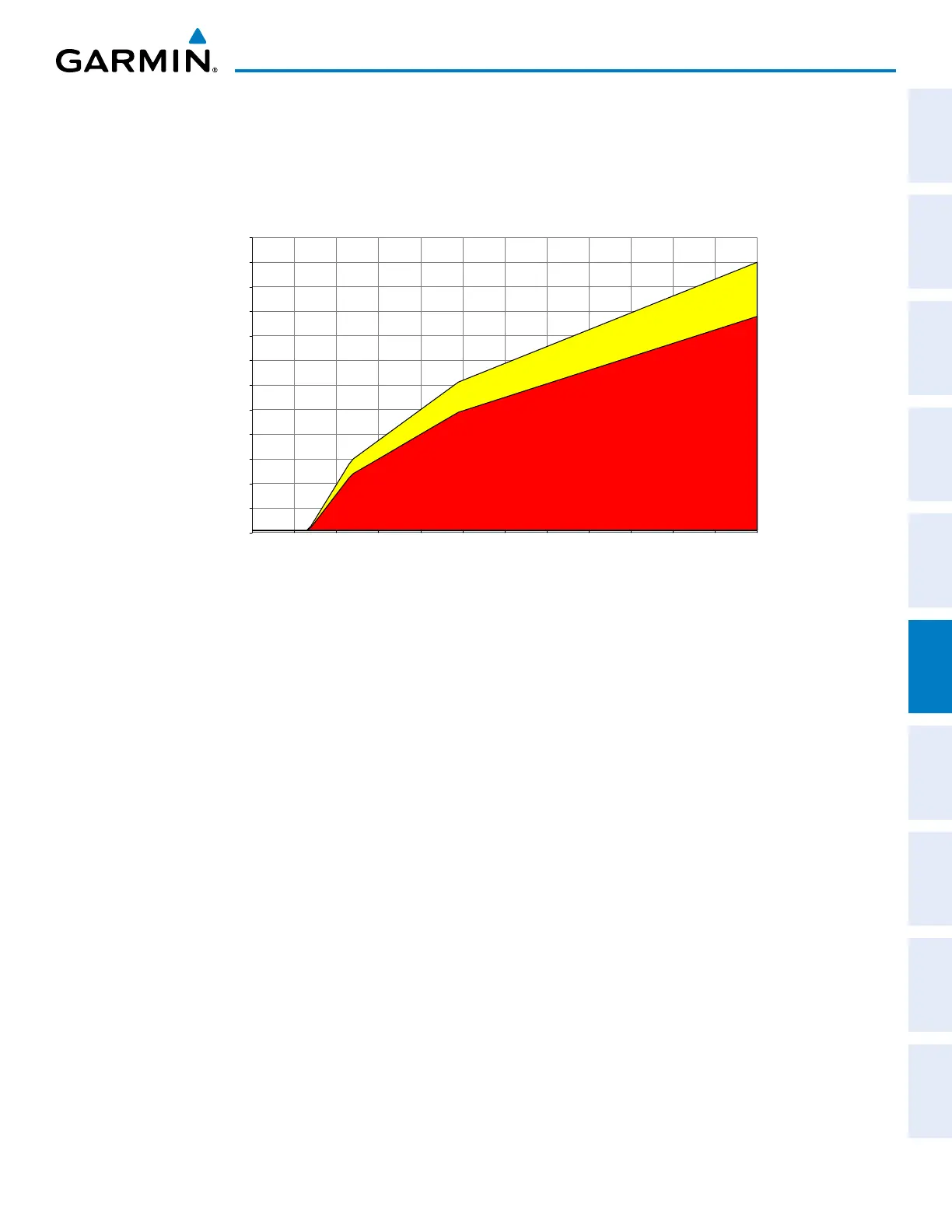
EXCESSIVE DESCENT RATE ALERT
The purpose of the Excessive Descent Rate (EDR) alert is to provide suitable notification when the
aircraft is determined to be closing (descending) upon terrain at an excessive speed. Figure 6-58 shows the
parameters for the alert as defined by TSO-C151b.
0
500
1000
1500
2000
2500
3000
3500
4000
4500
5000
5500
6000
0
1000
2000
3000
4000
5000
6000
7000
8000
9000
10000
11000
12000
Descent Rate (FPM)
Height Above Terrain (Feet)
Caution: “SINK RATE”
Warning: “PULL UP”
Figure 6-58 Excessive Descent Rate Alert Criteria
FORWARD LOOKING TERRAIN AVOIDANCE
The Forward Looking Terrain Avoidance (FLTA) feature of TAWS-B compares the aircraft’s projected flight
path with known terrain and obstacles in their respective databases and issues alerts as either a caution or a
warning:
Reduced Required Terrain Clearance (RTC) and Reduced Required Obstacle Clearance (ROC)
alerts are issued when the aircraft flight path is above terrain, yet is projected to come within the minimum
clearance values in Figure 6-59. When an RTC alert is issued, a potential impact point is displayed on the
TAWS-B Page.
Imminent Terrain Impact (ITI) and Imminent Obstacle Impact (IOI) alerts are issued when the
aircraft is below the elevation of a terrain or obstacle cell in the aircraft’s projected path. ITI and IOI alerts
are accompanied by a potential impact point displayed on the TAWS-B Page. The alert is annunciated when
the projected vertical flight path is calculated to come within minimum clearance altitudes in Figure 6-59.