GPSMAP
®
4000/5000 Series Owner’s Manual 31
Navigation
Navigation
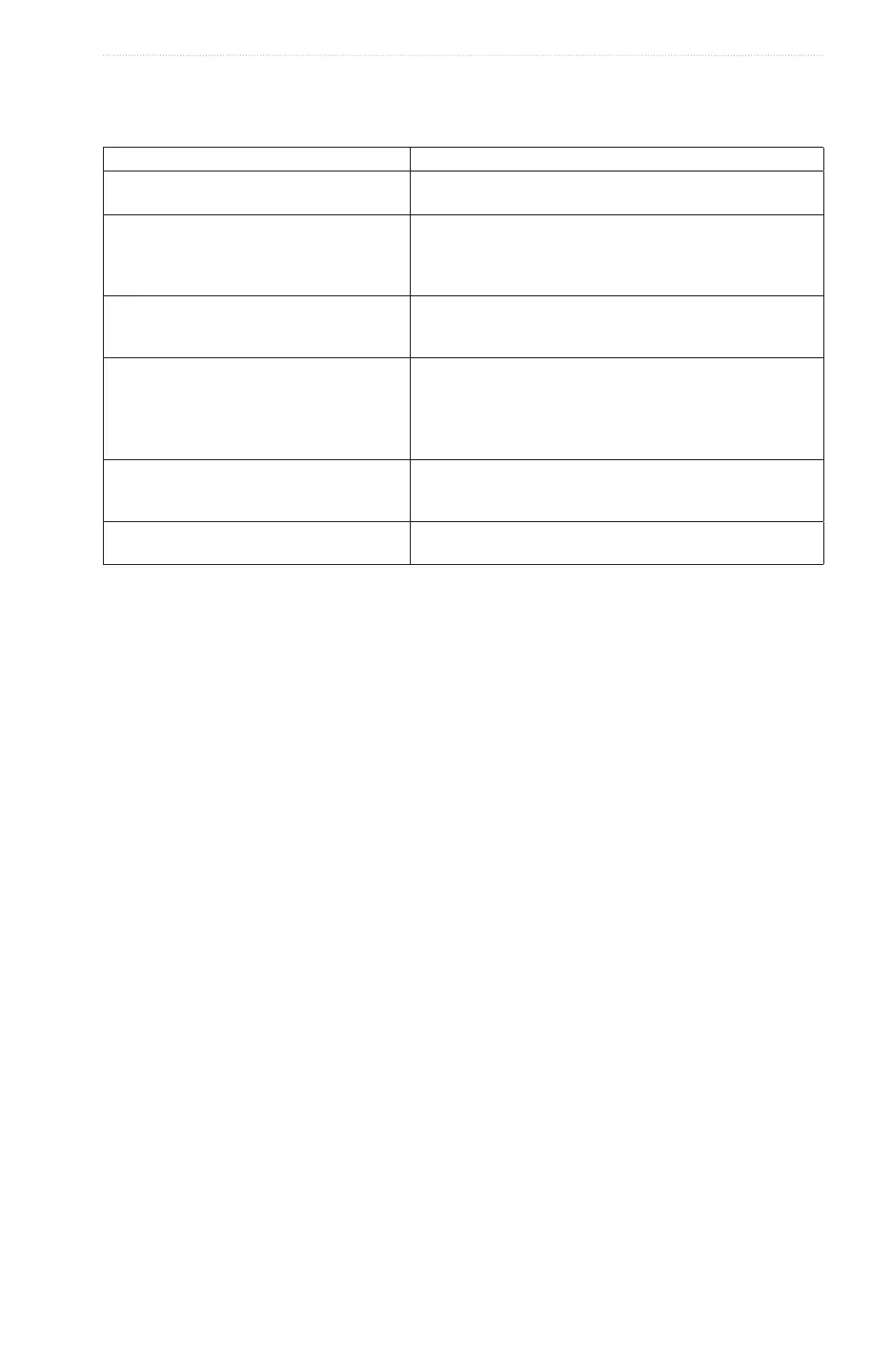
Basic Navigation Questions
Question Answer
How do I make the chartplotter point me in the
direction in which I want to go (bearing)?
Navigate using Go To� See “Setting and following a Direct
Course Using Go To” (page 32)�
How do I make the chartplotter giude me
along a straight line (minimizing cross track)
to a location using the shortest distance from
the present location?
Build a single-leg route and navigate it using Route To (page
34)�
How do I make the chartplotter guide me to a
location while avoiding obstacles?
Build a multi-leg roue and navigate is using Route To� See
“Creating and Navigating a Route from Your Present Location”
(page 34)�
How do I make the chartplotter steer my
automatic pilot?
Navigate using Route To (page 34)�
Note: To navigate a route created by the Auto Guidance
feature with an automaitc pilot, your chartplotter mych be
connected to a Garmin GHP series automatic pilot over a
NMEA 2000 network�
Can the chartplotter create a path for me? If you have a BlueChare g2 Vision data card, navigate using
Auto Guidance� See “Setting and Following a Course Using
Auto Guidance” (page 32)�
How do I change the Auto Gudance settings
for my boat?
See “Auto Guidance Line Congurations” (page 53)
Navigation with a Chartplotter
To navigate using a GPSMAP 4000 or 5000 series chartplotter, you must rst choose a destination, set a course
or create a route, and follow the course or route. You can follow the course or the route on the Navigation
Chart, the Fishing Chart, Perspective 3D, or Mariner’s Eye 3D.
: The Mariner’s Eye 3D chart view is available if you use a BlueChart g2 Vision data card. The Fishing
Chart is available if you use a BlueChart g2 Vision data card or a BlueChart g2 Data card, or if your built-in
map supports Fishing Charts.
Destinations
You can select destinations using the Navigation Chart or the Fishing Chart, or you can select a destination
using the Where To? feature.
Selecting a Destination Using the Navigation Chart
1. From the Home screen, select > .
2. Select the destination to which you want to navigate.
Selecting a Destination Using Where To?
1. From the Home screen, select .
2. Complete an action:
• Select to view a list of preloaded locations and locations you marked previously (page 32).
• Select to view a list of routes you saved previously (page 33).
• Select to view a list of recorded tracks (page 36).
• Select to view a list of marinas and other offshore points of interest, listed by name
(page 39).
• Select to search waypoints, routes, tracks, and offshore points of interest by name
(page 40).
3. Select a destination.
Courses
You can set and follow a course to a destination using one of three methods: Go To, Route To, or Guide To.
• —takes you directly to the destination.
• —creates a route from your location to a destination, allowing you to add turns along the way.