Do you have a question about the Garmin GPSmap 585 Plus and is the answer not in the manual?
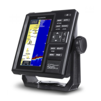
Physical dimensions and layout of the GPSMAP 585 Plus device.
Identification of the device's keys and card slot.
Details of the device's external connectors.
Explanation of the function of each key on the device.
Information on how to get support from Garmin.
Step-by-step guide for inserting memory cards.
Steps to update the device software using a memory card.
Selecting transducer type and adjusting chart zoom/pan.
Adjusting screen backlight and display color schemes.
Configuring device sounds and understanding GPS signal status.
Adding, rearranging, or removing items on the home screen.
Creating custom screen layouts by combining multiple views.
Editing and managing shortcuts for quick page access.
Adding screens for numbers, trip data, and graphs.
How data fields display information and how to configure them.
Viewing a full-screen graph of sonar readings.
Understanding the ClearVü scanning sonar display.
Explanation of traditional and CHIRP sonar technologies.
Details on ClearVü scanning sonar technology.
Viewing two frequencies and using shift-zoom for detail.
Manually or automatically adjusting the sonar zoom.
Locking the sonar screen to the water bottom.
Magnifying sonar images using digital or shift zoom.
Automatically adjusting sonar zoom based on bottom contour.
Adjusting settings to reduce sonar noise and clutter.
Marking locations directly from the sonar screen.
Choosing frequencies and saving presets for sonar.
Amplifying sonar signals for better detail or reducing clutter.
Adjusting sonar gain manually or using auto settings.
Customizing depth scale and adjusting the depth line.
Adjusting scroll speed and visual appearance of sonar data.
Accessing advanced sonar configuration options.
Reducing and identifying sources of sonar interference and noise.
Adjusting color intensity and compensating signal loss.
Customizing data displayed on the sonar screen.
Displaying compass and graphical data logs.
Overview of available chart and 3D view types.
Details on the Navigation Chart view.
Understanding the Perspective 3D chart view for navigation.
Detailed 3D views for navigation and underwater representation.
Fishing chart details and common chart symbols.
Accessing details about locations or objects on charts.
Guidance on navigating to specific points on a chart.
Accessing information about navigation aids like beacons and lights.
Customizing the appearance of charts and 3D views.
Managing marks, waypoints, and tracks on charts.
Displaying and managing information about other vessels.
Configuring how AIS vessel information is displayed.
Settings for navigation and fishing charts.
Displaying and customizing overlay data on charts.
Controlling navigation inset and editing data fields.
Adjusting the visual appearance of charts and 3D views.
Feature for creating custom bathymetric maps.
Settings for the Fish Eye 3D chart view.
Steps to record and create Quickdraw maps.
Managing saved Quickdraw contour maps.
Adjusting display and offset settings for Quickdraw contours.
How to connect and use the online community.
Uploading created maps to the community.
Retrieving maps shared by other users.
Definitions and capabilities of waypoints and marks.
Methods for creating marks and waypoints on the sonar screen.
Modifying existing saved waypoints.
Quickly marking and navigating back to a MOB location.
Following a saved waypoint.
Calculating distances between locations on the waypoint map.
Removing saved waypoints or MOB markers.
Transferring and sharing user data across devices.
Creating and navigating routes using the chart and waypoint list.
Modifying existing routes and accessing the route list.
Configuring track recording intervals and managing logs.
Bulk deletion of all saved waypoints, routes, and tracks.
Setting the display range for AIS targets.
Creating a waypoint at an AIS target's location.
Displaying AIS threats and organizing vessels into groups.
Adjusting how other vessels appear on the AIS radar.
Managing test alerts for AIS transmission.
Configuring an alarm for collision avoidance with AIS targets.
Using VRM and EBL to measure distance and bearing to targets.
Measuring distance and bearing to selected targets.
Customizing the visual appearance of the AIS radar.
How to access the highway page for navigation guidance.
Displaying and adjusting data on the highway screen.
Setting parameters for Auto Guidance path calculation.
Setting how close the Auto Guidance path stays to the shore.
Features enabled by connecting a VHF radio for DSC.
Activating DSC and viewing the DSC contact list.
Adding and managing DSC contacts.
Receiving alerts for DSC distress calls.
Navigating to a vessel that has sent a distress call.
Tracking vessels that send position reports.
Accessing details of position reports received.
Displaying trails of tracked vessels on the chart.
Setting up routine calls via VHF radio.
Choosing a channel for DSC communication.
Initiating routine calls using the chartplotter interface.
Viewing sunrise, sunset, moon phase, and sky view information.
Accessing tide and current data for specific stations.
Viewing moonrise, moonset, and moon phases.
Overview of the device's settings menu structure.
Accessing and configuring system-wide settings.
Viewing device information, software version, and event logs.
Configuring settings related to the vessel.
Compensating depth readings for keel position.
Compensating temperature and calibrating speed sensor readings.
Configuring navigation and system alarms.
Configuring alarms for navigation events like arrival and off-course.
Setting alarms for system events and sonar conditions.
Setting preferred units for measurements.
Configuring NMEA 0183 data output and settings.
Configuring route labels, auto guidance, and turn transitions.
Instructions for registering the device and using the sun cover.
Technical specifications of the GPSMAP 585 Plus device.
Steps to troubleshoot power-on and sonar functionality issues.
Resolving issues with waypoint creation accuracy.