Do you have a question about the Raymarine E140W and is the answer not in the manual?
Essential safety guidelines for operating the E-Series Widescreen display and related equipment.
Information on display characteristics and potential pixel variations in TFT LCD screens.
Precautions to prevent water intrusion and potential equipment failure due to moisture.
Limitations of the product and user responsibility for safe navigation practices.
Details on how Raymarine equipment conforms to Electromagnetic Compatibility regulations.
Importance of suppression ferrites for correct EMC performance and their proper installation.
Requirements for connecting Raymarine equipment to other devices using specific cables.
Statement declaring compliance with essential requirements of the EMC directive 2004/108/EC.
Guidelines for disposing of the product in accordance with the WEEE Directive.
Instructions on registering product ownership to receive full warranty benefits.
Information on the intended use of the equipment concerning maritime regulations.
Statement regarding the accuracy of information in the document and policy of product improvement.
Details about the handbook's content and the models it covers, assuming user knowledge.
Explains the terminology and conventions used within the user reference handbook for clarity.
Details connecting external devices to the multifunction display for enhanced features and functions.
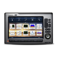
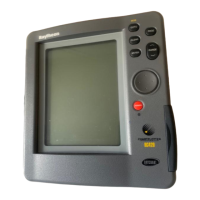
Identifies and describes the physical controls and screen items for operating the display unit.
Explains the Hybridtouch feature enabling operation via touchscreen and physical keys.
Details the benefits and functions that can be operated using the touchscreen interface.
Describes the home screen as a central access point to applications and data.
Explains how pages are used to display applications and can be customized.
Overview of available applications such as Chart, Fishfinder, and Radar.
Identifies and explains the components of the display screen, including databar and softkeys.
Procedure for editing data using the on-screen keyboard and relevant softkeys.
Covers placing cursors, selecting windows, and locking/unlocking the touchscreen.
Explanation of status symbols shown on the databar for connected equipment.
Guides through essential tasks before first use, including language, vessel details, and display settings.
Explains the use of CompactFlash cards for cartographic information and data archiving.
Instructions for transferring data between devices for backup and management.
Procedure for transferring waypoints and routes to/from external instruments using NMEA.
Defines waypoints, their display, features, and management within the system.
Details on building, navigating, and managing routes using waypoints.
Information on creating, reviewing, and editing tracks recorded on the display.
Details the storage limits for waypoints, routes, and tracks on the multifunction display.
Describes the chart application's features for navigation, planning, and viewing cartographic data.
Explains how vessel position and chart orientation (North Up, Head Up) are displayed.
Details the 2D and 3D chart views and how to manipulate them.
Features available for planning navigation, including building routes and managing tracks.
Options for navigating to locations, including goto cursor, follow route, and start track.
Instructions on using the ruler and cursor to measure distances and bearings on the chart.
Explanation of chart vectors for heading, COG, tide, and wind direction indicators.
Describes viewing animated current information and controlling animations.
How to display and search for additional information on cartographic objects, ports, and marinas.
Details available chart layers like aerial overlay, weather radar, and AIS targets.
Options affecting chart detail, synchronization, and fish mode display.
Guides on customizing chart and cartography settings for specific navigation needs.
Steps to enable and configure the autopilot control through the system setup.
Procedure for safely disengaging the autopilot and putting it into standby mode.
Details on engaging, disengaging, and controlling the autopilot using the display.
Description of autopilot control options like Engage Pilot, Clear Alarm, Standby, and Auto.
Information displayed in the autopilot dialog box, including status and waypoint details.
Identifies the various symbols indicating autopilot status modes like Standby, Track, and Auto.
Information on autopilot alarms and how to manage them for safe operation.
Instructions on activating and using the Man Overboard function to mark a person overboard.
Overview of system and application alarms, and how to configure alarm settings.
Introduction to radar usage for tracking targets and measuring distances and bearings.
Guide to selecting scan speed for HD and SuperHD digital radar scanners.
Identifies symbols indicating radar scanner power modes like Transmit, Standby, and Off.
Factors affecting radar range and image quality, including antenna height and target characteristics.
Explanation of the radar display elements, including range, databar, and target information.
Enables viewing two ranges simultaneously with HD and SuperHD scanners.
Describes radar orientation modes (Head Up, North Up, Course Up) for navigation.
Guide to tuning HD and SuperHD scanners for optimal radar picture quality.
Settings for tuning non-HD digital radomes for improved radar picture.
Instructions on using radar functions like range rings, cursor, VRMs, and EBLs for measurements.
Utilizing radar functions like Guard Zones and MARPA to track targets and prevent collisions.
Details on configuring radar scanner performance and behavior through the setup menu.
Explains the AIS feature for receiving vessel information and displaying targets in chart and radar.
Lists the required hardware and software for the AIS functionality.
Details the differences between AIS Class A and Class B data transmission.
Steps to enable AIS display within the chart and radar applications.
How to display COG/SOG vectors and heading indicators for AIS targets.
Identifies symbols used in the databar to indicate AIS unit status and operation.
Enables disabling AIS transmissions while still receiving data from other vessels.
How to display detailed information, vectors, and safety critical data for individual AIS targets.
Utilizing AIS safe zones and safety messages to help avoid collisions with other vessels.
Configuration options for AIS vector length, target history, and safe zones.
Information on AIS alarms for dangerous or lost targets and local alarm management.
Feature to notify when an AIS-equipped friend comes within range, configurable via a Buddy List.
Describes the CDI's graphical representation of vessel course for accurate steering to a waypoint.
Instructions on how to display the Course Deviation Indicator application on the home screen.
Guidance on monitoring course using the CDI's rolling road format and steering instructions.
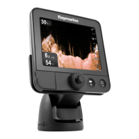
Overview of the fishfinder application, its features, and screen layout for seabed analysis.
Guidance on interpreting seabed structure and target representation in the fishfinder display.
Explains the use of four preset configurations for quick selection of optimal fishfinder settings.
Details on display modes like Zoom, Bottom Lock, and A-Scope for enhanced fishfinder viewing.
How to change the range of depth displayed and adjust the depth range settings.
Options to enhance the fishfinder display, including gain, power, VRM features, and scroll.
Instructions on placing, editing, and navigating to waypoints using the fishfinder display.
Configuration of fishfinder alarms for fish, depth, and sensitivity settings.
Accessing the fishfinder setup menu for configuring frequencies, display, and transducer settings.
Details on viewing key engine data, including gauges and digital information from compatible engines.
Instructions on accessing the engine monitor application from the home screen.
Steps for configuring the engine application, including number of engines and tachometer range.
Option to change the engine panel dial color between light and dark background.
Information on default data panels and cells used to display engine information.
Guides on customizing data panels by changing names, size, and displayed data items.
Describes the data application for viewing system and instrument data via NMEA or SeaTalk protocols.
Details on pre-configured data panels and cells for displaying various data types.
Information on displaying data from a compatible Airmar WeatherStation sensor.
Procedure for calibrating trim tabs and displaying trim tab data.
Guides on personalizing data panels by changing names, size, and displayed data items.
Explains the weather application's overlay of graphics and data for determining local conditions and forecasts.
Instructions on accessing the weather application from the home screen.
Steps required to set up the weather application, including Sirius subscription and graphics selection.
Describes the main features and graphics displayed in the weather application.
How to move around the weather map, place waypoints, and zoom.
Details on viewing various weather reports like tropical statements and marine warnings.
Functionality to monitor significant storms by viewing their tracks and forecasted positions.
How to view animated graphics for changing weather patterns, including forecasts and radar loops.
Describes controlling a connected Sirius Satellite Radio receiver for audio functions.
Instructions on accessing the Sirius Satellite Radio application from the home screen.
How to tune, browse, and scan Sirius Radio channels using the multifunction display.
Instructions on assigning Sirius Radio channels to presets for easier access to commonly used channels.
Feature to alert when a favorite song or artist plays, allowing setup of alerts.
How to block Sirius Radio channels and set up a password to prevent unauthorized access.
Explains how to view marine safety information, weather forecasts, and warnings via Navtex.
Steps to connect a Navtex receiver and configure NMEA options for receiving alerts.
Instructions for displaying, sorting, and selecting Navtex message alert categories.
Describes viewing video or camera sources directly connected to the multifunction display.
Guides on switching video sources, adjusting aspect ratio, and outputting video to an external display.
Explains connecting a DSC VHF radio to display distress messages and GPS position data.
Instructions to configure the display for showing messages from a DSC VHF radio.
Guides on selecting vessel icon type and size for display on the chart application.
Instructions for moving, resizing, and changing the data displayed in the databar.
Details various options within the System Setup menu for display configuration.
Information regarding servicing and repair, recommending authorized Raymarine dealers.
Recommends regular checks of cables for damage and secure connections for reliable operation.
Best practices for cleaning the product, including screen and case care.
Basic procedure for cleaning the display unit's case with a soft cloth.
Procedure for cleaning the display screen to avoid damaging its coating.
Details two types of reset operations: settings reset and settings and data reset.
Information on obtaining customer support via web, telephone, and dealer network.
Guidance on finding contact and support details for third-party suppliers like Navionics and Sirius.