Press the 4 POS function key. If the position reads N 00° 00.0000,
W 000° 00.0000, then the CDU was properly reset. If it does not, try the
procedure again.
A common source of memory corruption is when the Lithium memory back-up battery
gets depleted. This will result in either a slow deterioration of memory retention or it
may abruptly dump all its memory.
It is recommends the battery be changed every 2 to 3 years of operation by an
authorized technical dealer. Marine electronics dealers or radio shops will typically stock
the replacement Lithium battery, type TL-5902, 3.6V (1/2 AA).
GPS - GPS CDU Troubleshooting
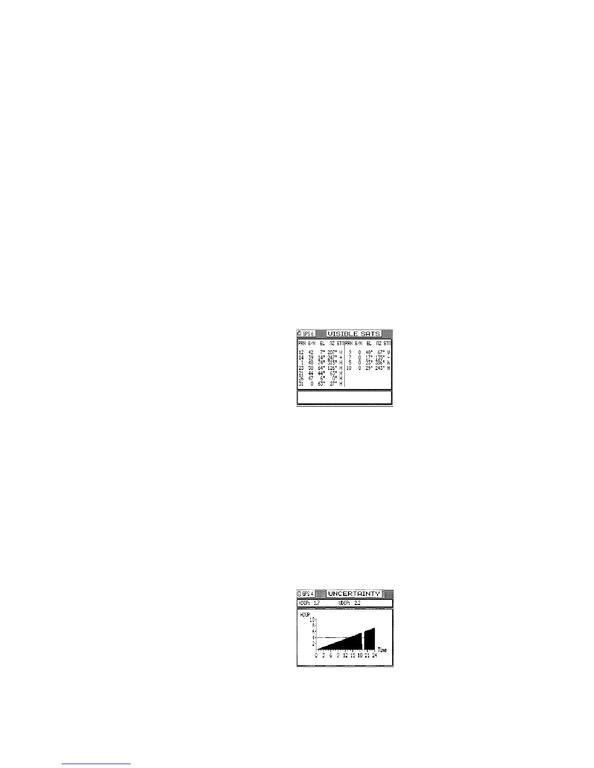
GPS3 - Visible Satellite Information
This screen provides some basic information about the MX Marine-SIMRAD smart GPS
antenna performance, in that it is basically an extension of GPS1 screen. It tells you
what satellites are available to track at the moment under the PRN number. The signal
strength of satellites under track is in the second column labeled S/N. The weakest
signal strength that the GPS receiver can track is 25. However, any satellite with a signal
strength under 32 is considered troubled, and the GPS receiver will not use that satellite
in the navigation solution. Troubled satellites tend to cause position jumps and greatly
reduce the accuracy of the GPS position fix.
The EL, AZ, and STA values represent the satellite’s Elevation and Azimuth, and Almanac
Status respectively.
Low signal to noise (S/N) quality numbers may be an indication of local interference
from on-board electronic equipment such as Radar, INMARSAT, VHF, SSB and other high
power transmitters. Review the installation of the entire system to ensure you have
followed proper procedures for cabling, power, and, most importantly, grounding and
antenna placement. The majority of these problems will be resolved by better grounding
and antenna location selection. Regarding grounding, the water intake for the engine, or
any other electrical ground relying on the engine or generator for Earth ground, is not
good for the GPS and especially the beacon receiver.
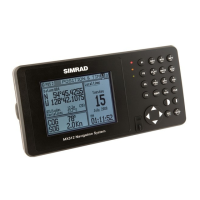
GPS4 - GPS Position Uncertainty
This screen presents a bar graph representing the HDOP for the past 23 hours. If you
are trying to do precision work or navigation in the same general area (within 100 miles)
as the day before, you can look at this screen to see when the best HDOP periods are.
The GPS constellation shifts back 4 minutes per day. That means you can expect the GPS
coverage to be virtually the same today as it was yesterday.
The small 1 hour gap in the bar graph represents the 24th hour. The gap is provided to
ease the readability of the bar graph for the present time. The dashed line extending
horizontally from the 4 represents the current HDOP Limit Alarm, which is set in CFG
Position. The current HDOP and VDOP values are given in the upper window.