23
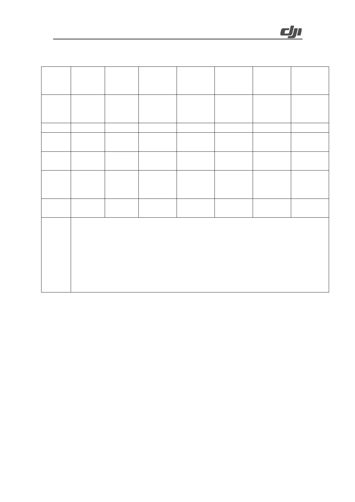
3.1.2.2.4. Recommended Route Parameters in Various Scenarios
High
Accuracy -
Plain Areas
High
Efficiency -
Plain Areas
High Accuracy -
Hilly Areas
High Efficiency
- Hilly Areas
High Accuracy -
Mountainous
Areas
High Efficiency
- Mountainous
Areas
Horizontal
flight
80-150 m
Horizontal
flight
150-200 m
Network DSM
follow
80-150 m
Network DSM
follow
150-220 m
Surveying-based
DSM follow
100-200 m
Network DSM
follow
200-220 m
Surveying-based
DSM follow
80-150 m
1. If you need to obtain more facade information about buildings or stronger penetrability, we recommend that you enable non-repetitive
scanning.
2. For forests with high crown densities (greater than 0.7), you can use cross routes to obtain the optimal penetrability. Cross routes can be
formed by creating two identical routes and then setting the main course angle of one route to ±90° so that the two routes are perpendicular
to each other. Flights along cross routes can effectively boost penetrability in dense forests.
3. For mountainous areas with big altitude differences, we recommend that you set routes vertical to contour lines to ensure the evenness of
point clouds. Compared with routes parallel to contour lines, routes vertical to contour lines have lower efficiency but better modeling
effects.
Ø Plain areas: A plain area is a mapping area whose biggest altitude difference is smaller than
20% of the flight altitude. For example, if the biggest altitude difference of a mapping area is
smaller than 20 m and the flight altitude is 100 m, this mapping area is a plain area.
Ø Hilly areas: A hilly area is a mapping area whose biggest altitude difference falls between 20%
and 40% of the flight altitude. For example, if the biggest altitude difference of a mapping area
is between 20 and 40 m and the flight altitude is 100 m, this mapping area is a hilly area.
Ø Mountainous areas: A mountainous area is a mapping area whose biggest altitude difference
is larger than 40% of the flight altitude. For example, if the biggest altitude difference of a
mapping area is greater than 40 m and the flight altitude is 100 m, this mapping area is a
mountainous area.
3.1.2.3. Flight Data Collection
3.1.2.3.1. Pre-flight Check
On the map view, tap the start icon to enter the pre-flight check screen. Ensure that the remote
 Loading...