Garmin G950 Pilot’s Guide for the Pilatus PC-6
190-00870-02 Rev. A
336
HAZARD AVOIDANCE
SYSTEM
OVERVIEW
FLIGHT
INSTRUMENTS
EIS
AUDIO PANEL
& CNS
FLIGHT
MANAGEMENT
HAZARD
AVOIDANCE
AFCS
ADDITIONAL
FEATURES
APPENDICESINDEX
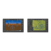
Customizing terrain and obstacle display on the Navigation Map Page:
1) Select the Navigation Map Page.
2) Press the MENU Key.
3) With ‘Map Setup’ highlighted, press the
ENT
Key (Figure 6-50).
4) Turn the small FMS Knob to select the ‘Map’ Group and press the ENT Key (Figure 6-51).
5) Turn the large
FMS
Knob or press the
ENT
Key to scroll through product selections (Figure 6-52).
• TERRAIN DATA – Turns the display of terrain data on or off and sets maximum range at which terrain is shown
• OBSTACLE DATA – Turns the display of obstacle data on or off and sets maximum range at which obstacles are shown
6) Turn the small
FMS
Knob to scroll through options for each product (ON/OFF, range settings).
7) Press the
ENT
Key to select an option.
8) Press the FMS Knob or CLR Key to return to the Navigation Map Page with the changed settings.
Figure 6-51 Navigation Map Page Setup Menu
Figure 6-50 Navigation Map Page Menu
Figure 6-52 Navigation Map Page Setup Menu, Map Group