Enter the traffic circle (second next maneuver).
Approaching a waypoint on the right.
Approaching the destination.
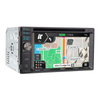
2.3.6 Lane information and signposts
When navigating on multi-lane roads, it is important to take the appropriate lane in order to follow the
planned route. If lane information is available in the map data, the VX7020A displays the lanes and
their directions using small arrows at the bottom of the map. Highlighted arrows represent the lanes and
the direction you need to take.
Wh
ere additional information is available, arrows are replaced by signposts. Signposts are displayed at
the top of the map. The color and style of the signposts are similar to the real ones you can see above
roads or by roadsides. They show the available destinations and the road numbers.
All signposts look similar when cruising (when there is no planned route). During navigation only the
signpost that points to the lane(s) to be taken is highlighted; all the others are darker.
If you want to hide the currently displayed signposts, tap any of them and the normal Navigation view
returns until new signpost information is received.
You can modify the signpost settings in
(page 81).
17