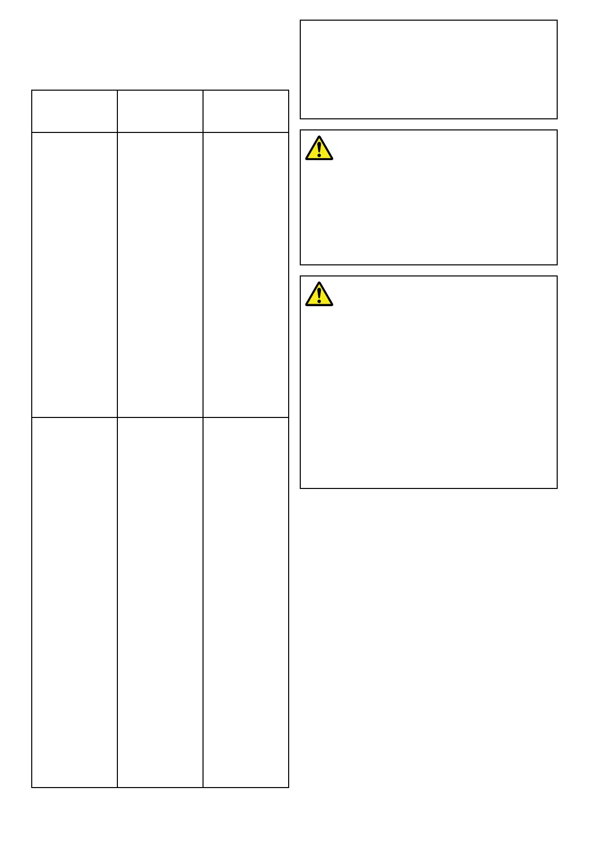
DifferencesbetweenAutoroutingandEasy
Routing
Thereareimportantdifferencesbetweentheway
Navionics
®
andJeppesen
®
handleautomaticroute
generation.
Navionics
®
Autorouting
C-MAPby
Jeppesen
EasyRouting
Tidalheight—
Depthclearance
Autorouting
avoidsshallow
areasbasedon
theuserdened
MinimumSafe
Depthsetting
plusanadditional
Navionics
safetymargin.
Autorouting
assumesthe
lowesttidelevel,
normallyLowest
AstronomicalTide
(LAT).Thetidecan
belowerthanLAT
duetoatmospheric
effectssuchas
highairpressure,
winddirection,etc.
EasyRouting
assumesthatthere
willbesometide.
Theusermust
applytheirown
safetymarginas
appropriateto
currentconditions.
Routelegsthat
crossareas
shallowerthan
theuserdened
MinimumSafe
Depthsetting
aremarkedwith
hazardwaypoint
symbols,itis
criticalthatthese
legsarechecked
toensurethat
thereissufcient
tidetoavoidthe
hazard.
Beam/Height
constraints
Autoroutingdoes
notusetheuser
denedMinimum
SafeBeamor
MinimumSafe
Heightsettingsto
generateroutes.
Objectswithbeam
/heightconstraints
aremarkedwith
hazardwaypoint
symbols,itis
criticalthatthese
legsarechecked
toensurethat
thereissufcient
clearancetoavoid
thehazard.
EasyRouting
usestheuser
denedMinimum
SafeBeamand
MinimumSafe
Heightsettings
todetermine
ifsufcient
clearanceis
available.The
usermust
applythereown
safetymarginas
appropriateto
currentconditions.
TheHeightdatum
mustbechecked,
asitcouldbe
MeanHighWater
Springs(MHWS)
orHighest
AstronomicalTide
(HAT).Inboth
casesthetidecan
behigherthan
thedatumdue
toatmospheric
effectssuchas
highairpressure,
winddirection,etc.
Caution:EasyRouting-Dredged
areas
TheJeppesenEasyRoutingfeaturewill
ignoresomehazardsindredgedareas.
EasyRoutingisintendedforpassage
planningbetweenharborsratherthan
withinaharbor.
Warning:Automaticroute
generation
Routescreatedusingautomaticroute
generationrelyondatatakenfrom
compatibleelectroniccartographyand
userdenedsettings.Asbothofthese
valuesaresubjectivethegenerated
routeMUSTbecarefullycheckedand
ifnecessaryeditedBEFOREstartingto
followtherouteintheChartapplication.
Warning:Trafcseparation
Automaticroutegenerationfeatures
donotadheretotheTrafcSeparation
SchemesidentiedinRule10ofthe
InternationalRegulationsforPreventing
CollisionsatSea1972asamended.
Raymarine
®
thereforerecommends
thatyoudoNOTuseAutomaticroute
generationtocreateanypartofaroute
whichwillcrosstrafclanesorpass
neartotrafcseparationlines.Inthese
situationsAutomaticroutegeneration
MUSTbeswitchedOffandtheroute
orroutelegMUSTbebuiltmanually,
ensuringcompliancetotheruleslaidout
intheaboveregulations.
Buildingarouteusingautomaticroute
generation
Automaticroutegenerationcanbeusedtocreatean
entirerouteorcanbeactivatedatanytimewhen
buildinganewroute.
FromtheChartapplication:
1.SelectBuildRoutefromthechartcontextmenu
ortheNavigatemenu.
TheBuildRoutemenuisdisplayed.
2.SelectAutorouting/EasyRoutingsothatOn
isselected.
Autorouting/EasyRoutingcanbeswitched
OnandOffatanytimeduringroutebuilding.
154
LightHousemultifunctiondisplayoperationinstructions

 Loading...


