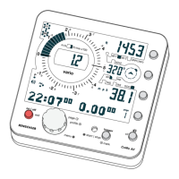
2.8.4 Position and Altitude Display (page 5)
Position is shown in degrees of longitude and latitude. The GPS
uses the world cup standard format WGS 84
(degreedegree,decimaldecimaldecimaldecimaldecimal) to display
the position.
There is no indication in minute- or second-format yet.
Knowing your position in degrees of longitude and latitude is
useful when you have to guide people in case of emergency, or
just to bring you back after a cross country flight.
For technical reasons altitude determination by GPS is less precise
than the analysis of the geographic position. GPS-altitude is
shown with a significant delay after the position is found. At
first, values are rather inaccurate (aberrations of up to 50 m!).
After a while of operation the GPS-altitude becomes more exact.
Warning: Given the lack of accuracy of the GPS altitude reading,
regard it as only an approximate value when adjusting the
barometric altimeter.
21
2.8.3 Satellite-State-Indication
This indication keeps you informed about GPS-reception. If the
core of the indication flashes, the GPS is in search-mode. For
every satellite found, one dot lights up. Although your GPS is
capable of receiving up to 16 satellites, the indication only shows
up to 6. More than six satellites are not necessary.
flashing core = search for satellites
- no position displayed
one more dot for each satellite found.
4 satellites found, flashing stops.
- sufficient reception for position analysis
6 -12 satellites found
- perfect reception
GPS Page
GPS-altitude
Position