At this time, you need to follow the prompts to pick up the
aircraft at a distance of 1m from the ground and rotate the aircraft
horizontally for 1-2 laps until the APP interface prompts to enter the
vertical calibration.
When the drone is turned on,
it will automatically enter the
calibration process. You only
need to perform this step when
you need to recalibrate.
Pick up the aircraft at a distance of 1m from the ground, and
rotate the aircraft 1-2 laps vertically with the camera facing upwards
until the prompt of vertical calibration on the APP interface
disappears. After the compass calibration is completed, place the
aircraft on a level ground. At this time, the front arm of the aircraft
has a white light and the rear arm has a blue light, and the App
prompts that the compass calibration is complete.
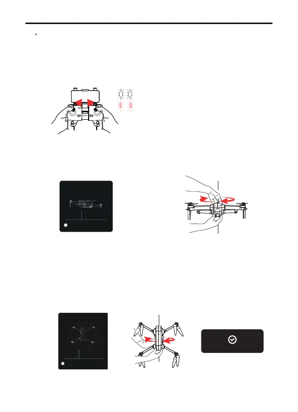
Match the aircraft with the transmitter and mobile phone
Push the left rocker of transmitter to the "1 o'clock" position and
the right rocker to the "11 o'clock" position, the light of the arm
flashes quickly, the light of the front arm is white and the light of the
rear arm is white pink;
Copyright ©2023 Ruko All Rights Reserved.
46
F11 PRO User Manual
③
①
②
front
rear
GeomagneticHor Calibration
Plaese place the aircraft 1 meter high
on the groud and rotate it
horizontally for 2-3times .
3.28ft
1
GeomagneticHor Calibration
Please place the airctaft 1 meter high on
the ground, nose up, and rorate it 2-3
times.
3.28ft
2
Geocalibration finished!