Chapter 3-22 CR34/44/54 Radar menu
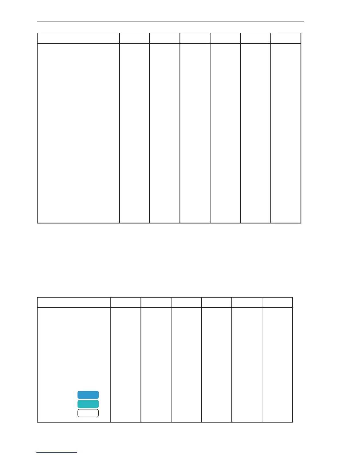
C-MAP features
Overlay Full *Custom Simple Fishing Low
Marine:
Names
Nav-Aids
Light Sectors
Attention Areas
Tides, currents
Nature of seabed
Ports
Tracks, routes
Buoys
Signals
Land:
Natural features rivers
Natural features
Cultural features
Landmarks
Chart:
Grid
Boundary lines
Mixing levels
Declutter
OFF
INT
OFF
ON
ON
ON
OFF
ON
ON
ON
OFF
OFF
OFF
OFF
AUTO
OFF
ON
ON
ON
INT
ON
ON
ON
ON
ON
ON
ON
ON
ON
ON
ON
ON
AUTO
AUTO
ON
ON
OFF
INT
OFF
ON
ON
ON
OFF
ON
ON
ON
OFF
OFF
OFF
OFF
AUTO
OFF
ON
ON
ON
INT
OFF
ON
ON
OFF
ON
OFF
ON
ON
ON
OFF
OFF
ON
AUTO
AUTO
OFF
ON
ON
INT
OFF
ON
OFF
ON
OFF
OFF
ON
ON
OFF
OFF
OFF
OFF
AUTO
OFF
ON
ON
OFF
INT
OFF
OFF
OFF
OFF
OFF
OFF
OFF
OFF
OFF
OFF
OFF
OFF
AUTO
OFF
OFF
ON
Group: Depth - specifies the presentation of depth lines, levels, etc. on chart
The default settings in this group are fixed in all display modes, except for
*Custom where it is possible by the user to alter the features. The color indica-
tion for depth levels 1, 2 and 3 is determined by the color palette in the SETUP
menu.
C-MAP features
Overlay Full *Custom Simple Fishing Low
Soundings
Underwater objects
Depth Lines
Depth Lines>
Depth Lines<
Depth Areas
Depth
Level 1
Level 2
Level 3
OFF
OFF
ON
0000m
9999m
ON
0-002m
2-009m
9-MAX
ON
ON
ON
0000m
9999m
ON
0-002m
2-009m
9-MAX
OFF
OFF
ON
0000m
9999m
ON
0-002m
2-009m
9-MAX
ON
ON
ON
0000m
5m
ON
0-002m
2-009m
9-MAX
ON
ON
ON
0000m
9999m
ON
0-002m
2-009m
9-MAX
OFF
ON
OFF
0000m
5m
OFF
0-002m
2-009m
9-MAX