Do you have a question about the ComNav SinoGNSS T300 PLUS and is the answer not in the manual?
Overview of the T300 PLUS GNSS receiver and its capabilities.
Key features and specifications of the T300 PLUS GNSS receiver.
Detailed list of components included in the T300 PLUS receiver package.
Recommended operating and storage conditions for optimal receiver performance.
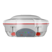
Explanation of the indicators and buttons on the front panel of the receiver.
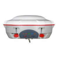
Description of ports and features located on the lower part of the receiver.
Information on internal and external power options and battery charging.
Instructions for mounting the receiver onto a range pole for fieldwork.
Details on the functions of the power and record buttons on the receiver.
Explanation of the status indicators (LEDs) on the receiver's front panel.
How to view system, network, position, and satellite information via the web GUI.
Settings for satellite tracking, work mode, and antenna setup via the web GUI.
Options for managing receiver data, firmware, and utility functions.
Remote control functions like rebooting and resetting the receiver to factory defaults.
Procedures for updating the receiver's system and radio firmware.
Configuring the receiver for static surveys using the Compass Receiver Utility (CRU).
Steps and recommendations for collecting static survey data accurately.
How to download raw static observation data from the receiver to a PC.
Converting raw observation data from ComNav binary to RINEX format.
Guide to installing the Survey Master software on a controller.
Using the wizard to quickly learn and start RTK survey workflows.
Creating or selecting projects and managing coordinate systems within Survey Master.
Establishing a Bluetooth connection between Survey Master and the T300 PLUS receiver.
Setting up RTK surveys using the receiver's internal radio communication.
Extending RTK working distance using external radio communication.
Receiving correction data via PDA's GPRS or Wi-Fi for RTK surveys.
Using the receiver's internal GPRS for Point-to-Point or Ntrip client modes.
Transmitting correction data from base to server for rover access.
Acquiring correction data from Ntrip(CORS) servers via the receiver's 4G module.
Performing topographic surveys by collecting point data.
Configuring parameters for static and tilt surveys, including accuracy and naming.
Utilizing the IMU sensor for tilt measurements and pole plumb compensation.
Conducting continuous surveys based on time/distance or computing survey area.
Guiding users to specific points or lines on a map for staking operations.
Post-processing kinetic measurements for dynamic surveying applications.
Calibrating the receiver to a known datum system using measured points.
Adjusting base station position within a project for grid coordinate system changes.
Calculating points, lines, and angles directly in the field using COGO functions.
Importing predefined or user-defined data formats into Survey Master.
Exporting survey points and data in various formats like CSV, DXF, KML.
Importing DXF/DWG/SHP files as basemaps for survey guidance.
Configuring the receiver to output NMEA data via Lemo port or Bluetooth.
Registering the T300 PLUS receiver using provided codes via Survey Master.
Updating receiver firmware using a PC connection via serial cable.
Updating receiver firmware wirelessly using the WIFI firmware update tool.
| RTK Positioning Accuracy | Horizontal: 8 mm + 1 ppm RMS; Vertical: 15 mm + 1 ppm RMS |
|---|---|
| Static Positioning Accuracy | Horizontal: 2.5 mm + 0.5 ppm RMS; Vertical: 5 mm + 0.5 ppm RMS |
| Operating Temperature | -40°C to +65°C |
| Storage Temperature | -55°C to +85°C |
| IP Rating | IP67 |
| Frequency Bands | GPS L1, L2, L5; GLONASS L1, L2; Galileo E1, E5a, E5b; QZSS L1, L2, L5 |
| Data Update Rate | 1Hz to 50Hz |
| Communication Interfaces | Bluetooth, Wi-Fi |
| Battery Life | Up to 10 hours |
| Data Storage | 8 GB internal memory |
| Tilt Sensor | Yes |