Do you have a question about the ComNav SinoGNSS T300 and is the answer not in the manual?
Overview of T300 GNSS receiver capabilities and features, highlighting its performance in harsh environments.
Lists the key features and specifications of the T300 GNSS receiver, including its size, weight, and channel count.
Details the components included in the T300 receiver's basic supply kit and optional kits.
Specifies the operating and storage conditions for optimal receiver performance and longevity.
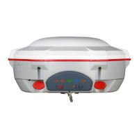
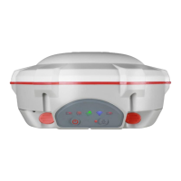
Describes the indicators and buttons on the receiver's front panel for status monitoring.
Details the ports and compartments located on the receiver's lower housing.
Explains the receiver's internal and external power supply options and battery management.
Guides on how to mount the receiver onto a range pole for field use.
Explains the functions of the power and record buttons on the receiver.
Describes the meaning of different LED indicator states for receiver status.
Guides on configuring the receiver using the Compass Receiver Utility software.
Guidelines for collecting static survey data to achieve millimeter accuracy.
Covers downloading, converting, and managing static survey data.
Guides on installing the CGSurvey software on the controller.
Instructions on creating a new project within CGSurvey software.
Steps to establish Bluetooth connection between controller and T300 receiver.
Details using receiver's internal radio for RTK communication.
Explains extending RTK working distance using external radio.
Describes receiving correction data via PDA's GPRS or Wi-Fi for RTK survey.
Details using receiver's internal GPRS for Point to Point, Ntrip, or Phone Call modes.
Instructions on measuring points using CGSurvey software.
Explains Post Processing Kinematic (PPK) survey method and its setup.
Guides performing continuous topographic surveys with the receiver.
Details staking out points in the field using the receiver.
Describes Coordinate Geometry (COGO) functions in CGSurvey.
Covers site calibration for coordinate system conversion and grid reset.
Instructions for exporting measured points from CGSurvey to PC.
Guides importing points from file into CGSurvey project.
| Tilt Sensor | Yes |
|---|---|
| Waterproof/Dustproof | IP67 |
| Positioning Accuracy (RMS) - Static | Horizontal: 2.5mm + 0.5ppm, Vertical: 5mm + 0.5ppm |
| Positioning Accuracy (RMS) - RTK | Horizontal: 8 mm + 1 ppm Vertical: 15 mm + 1 ppm |
| Data Format | NMEA-0183, RTCM3.x, CMR, CMR+ |
| Data Update Rate | Up to 20 Hz |
| Communication | Bluetooth, Wi-Fi, 4G, Ethernet |
| Battery | Rechargeable Li-ion battery |
| Operating Temperature | -40 °C to +75 °C |
| Power Supply | 6-36 V DC external power input |
| Signal Tracking | GPS L1/L2, GLONASS L1/L2, BeiDou B1/B2, Galileo E1/E5 |