18
©
2021
DJI All Rights Reserved.
Flight Mission Usage
The P1 supports Mapping, Oblique, Linear Flight, and Waypoint missions. Smart Oblique and Terrain
Follow can be enabled in Mapping mission.
Preparation
1. Make sure the P1 is installed correctly on the aircraft and that the aircraft and remote controller are
linked after powering on.
2. Go to camera view in DJI Pilot, select
, then RTK, choose the RTK service type, and make sure
that the status of the RTK positioning and heading are both FIX.
3. Set the RTH altitude, Home Point, and Failsafe behavior based on the obstacles within the ight
route. When ying near a GEO zone, it is recommended to set the ight altitude at least 5 meters
below the altitude limit of the GEO zone.
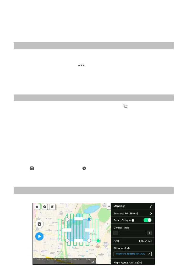
Mapping Mission
1. Enter the mission ight screen in DJI Pilot, select Create Mission, and to choose a Mapping mission.
Tap and drag on the map to adjust the area that will be scanned and tap “+” to add a waypoint.
2. Edit parameters:
A. Select Zenmuse P1 (35mm) as the camera type according to the lens type. A 35mm lens is used
as an example.
B. Set the altitude, takeo speed, route speed, the action upon completion, and enable elevation
optimization.
C. In Advanced Settings, set the side overlap ratio, forward overlap ratio, course angle, margin, and
photo mode.
D. In Payload Settings, set the focus mode and dewarping.
During an orthophoto operation, it is recommended to adjust the route speed to the maximum value and
enable elevation optimization. Set the focus mode to First Waypoint Autofocus and disable dewarping.
3. Select
to save the mission and select to upload and execute the ight mission.
4. Power o the aircraft after the mission is completed and remove the SD card from the P1. Connect
it to a computer and check photos and les.
Smart Oblique
Smart Oblique can be enabled in Mapping mission.
224.8m
224.8m
245.8m 245.8m
S
H20 T
6277 m 41 m 49 s 102 697
55549.0
-45°
12
2.4G
80%
100%
26.1v
26.1v
 Loading...