Do you have a question about the Eagle IntelliMap 320 and is the answer not in the manual?
Details the technical specifications and features of the IntelliMap 320 unit.
Explains the fundamental principles of GPS operation and how the unit functions.
Step-by-step guide for installing the GPS antenna and receiver module.
Instructions for safely connecting the unit to a power source.
Mounting procedures using the provided gimbal bracket.
Methods for flush-mounting the unit into a dashboard.
Options for using the unit in a portable configuration.
How to insert and use memory cards for data storage.
Information on additional accessories available for the unit.
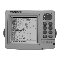
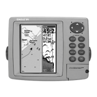
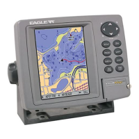
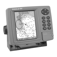
Explains the function of each key on the device.
Instructions for turning the unit on, off, and adjusting backlight levels.
Overview of the main menu commands and their functions.
Describes the three main page displays: Satellite Status, Navigation, and Map.
Displays detailed satellite lock-on and position acquisition status.
Shows compass rose, direction of travel, and navigation data.
Displays a bird's-eye view of the map with course and track.
Compares the detail levels of the background map and custom MapCreate maps.
Learn to measure distances between locations on the map.
Create, manage, and navigate to custom icons on the map screen.
Plan, create, save, and navigate complex routes using waypoints.
Create, save, edit, and navigate recorded trails.
Access tools like alarm clock, trip calculator, and sun/moon data.
Create, edit, delete, select, and set waypoints for navigation.
Set up and customize arrival, off-course, and anchor alarms.
Manage satellite lock-on and view DGPS signal status.
Tailor map appearance, data elements, and orientation for clarity.
Display and interpret Navionics electronic charts and port services.
Restore factory default settings for all system features.
Optimize display visibility by adjusting contrast and brightness.
Configure the unit's time, date, and menu language settings.
Control trail recording, display, and smoothing for accurate path tracking.
Configure speed, distance, depth, temperature, and heading units.
Search for specific street addresses within the unit's database.
Find nearby highway exits and associated services.
Locate businesses, landmarks, and other points of interest on the map.
Search for specific streets and their intersections.
Search for and locate previously saved waypoints.
Lists the geodetic datums supported by the GPS unit.
Details compliance with Federal Communications Commission rules.
Information on product licensing, warranty terms, and how to obtain service.
| Screen Type | TFT LCD |
|---|---|
| Display Resolution | 320 x 240 pixels |
| Battery Life | Up to 8 hours |
| Map Coverage | North America |
| Weight | 5.3 oz (150 g) |
| Touchscreen | No |
| Preloaded Maps | Yes |
| Receiver | High-sensitivity GPS |